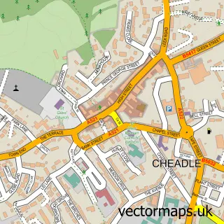
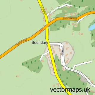
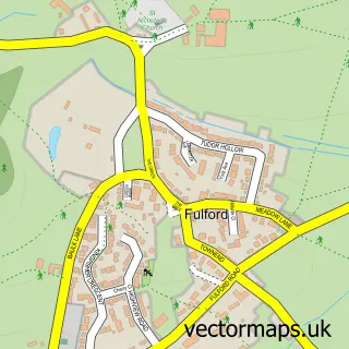
This Blythe Bridge street map is a detailed vector street map covering a 750m x 750m area. Select a larger area to create and download your own vector street map of Blythe Bridge.
The 750-metre map sample for Blythe Bridge covers 345 mapped buildings and approximately 11.2 km of road detail, of which 22 named roads are named. The immediate area includes 1 primary school and 1 secondary school, 1 railway station, 5 GP surgeries within 2 miles and 6 MOT stations within 2 miles. The wider area around Blythe Bridge features 1 food and drink venue. To create a larger or custom map of Blythe Bridge, the map builder lets you define your own coverage area and download editable SVG, PDF and PNG files.
Create a larger editable map of Blythe Bridge
Choose any area you need and generate a high-quality vector map instantly. Perfect for print, planning, design, business and personal use.

This Blythe Bridge street map in Staffordshire is available as downloadable SVG, PDF and PNG map files, or as a printed map for planning, business, display, education, local information and design work. You can also create a larger custom map area using the map selector.
What this Blythe Bridge map sample shows
Blythe Bridge lies within Forsbrook Cp parish, part of Forsbrook ward in the Staffordshire Moorlands District local authority area. The postcode geography for this area includes the ST postcode area, the ST11 postcode district and the ST11 9 postcode sector. Residents fall under the Nhs Staffordshire And Stoke-On-Trent Integrated Care Board for NHS services.
Local features near Blythe Bridge
Within 2 milesAmenities and services in and around Blythe Bridge.
Administrative and postcode information for Blythe Bridge
Blythe Bridge lies within Forsbrook Cp parish, part of Forsbrook ward in the Staffordshire Moorlands District local authority area. The postcode geography for this area includes the ST postcode area, the ST11 postcode district and the ST11 9 postcode sector. Residents fall under the Nhs Staffordshire And Stoke-On-Trent Integrated Care Board for NHS services.
Nearby street map samples around Blythe Bridge

More street maps in Staffordshire
750 metre map area coverage
Boundary, postcode and point of interest information for the 750m x 750m rectangle centred on this sample map.
Boundaries containing map centre
Constituency: Stoke-on-Trent South Co Const
County: Staffordshire County
District: Staffordshire Moorlands District
Icb: NHS Staffordshire and Stoke-on-Trent ICB
Parish: Forsbrook CP
Police Force: staffordshire
Postcode District: ST11
Postcode Sector: ST11 9
Ward: Forsbrook Ward
Nearby boundaries intersecting sample
Constituency: Staffordshire Moorlands Co Const
Parish: Caverswall CP
Ward: Caverswall Ward
Postcode coverage
POI category counts
Anglican Church: 2
Elementary School: 2
Library: 2
Train Station: 2
Art Gallery: 1
Auto Electrical Repair: 1
Beauty And Spa: 1
Beauty Salon: 1
Building Supply Store: 1
Business Manufacturing And Supply: 1
Sample points of interest
- St. Peter's Church
- St. Peter's Forsbrook
- Michael's Art Gallery
- Cam-Tec Ltd.
- SB Aesthetics
- Shaper's Hairdressers
- Kilgannon
- Paving UK
- Premier Flooring Distribution
- Woof And Ready
- Blythe TV Services
- Forsbrook C E
Create a larger editable map of Blythe Bridge
This sample shows only a 750 metre area. To create a larger map of Blythe Bridge, use our map builder to choose your own coverage area, add titles and download editable SVG, PDF and PNG files.
Create a custom map of Blythe Bridge