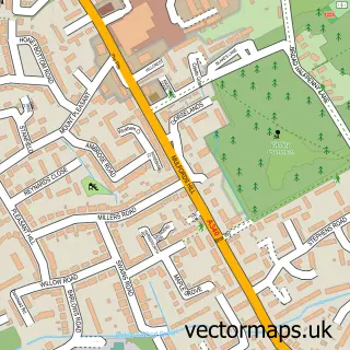
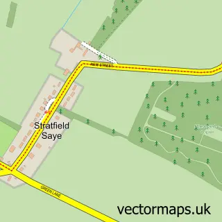
This Bramley street map is a detailed vector street map covering a 750m x 750m area. Select a larger area to create and download your own vector street map of Bramley.
The 750-metre map sample for Bramley covers 462 mapped buildings and approximately 16.3 km of road detail, of which 31 named roads are named. The immediate area includes 1 school, 1 railway station, 1 GP surgery within 2 miles and 1 pub among other local services. The wider area around Bramley features 1 tourism point of interest and 3 food and drink venues. To create a larger or custom map of Bramley, the map builder lets you define your own coverage area and download editable SVG, PDF and PNG files.
Create a larger editable map of Bramley
Choose any area you need and generate a high-quality vector map instantly. Perfect for print, planning, design, business and personal use.

This Bramley street map in Hampshire is available as downloadable SVG, PDF and PNG map files, or as a printed map for planning, business, display, education, local information and design work. You can also create a larger custom map area using the map selector.
What this Bramley map sample shows
Bramley lies within Bramley Cp parish, part of Bramley And Sherfield ward in the Basingstoke And Deane District (B) local authority area. The postcode geography for this area includes the RG postcode area, the RG26 postcode district and the RG26 5 postcode sector. Residents fall under the Nhs Hampshire And Isle Of Wight Integrated Care Board for NHS services.
Local features near Bramley
Within 2 milesAmenities and services in and around Bramley.
Administrative and postcode information for Bramley
Bramley lies within Bramley Cp parish, part of Bramley And Sherfield ward in the Basingstoke And Deane District (B) local authority area. The postcode geography for this area includes the RG postcode area, the RG26 postcode district and the RG26 5 postcode sector. Residents fall under the Nhs Hampshire And Isle Of Wight Integrated Care Board for NHS services.
Nearby street map samples around Bramley


More street maps in Hampshire
750 metre map area coverage
Boundary, postcode and point of interest information for the 750m x 750m rectangle centred on this sample map.
Boundaries containing map centre
Constituency: North East Hampshire Co Const
County: Hampshire County
District: Basingstoke and Deane District (B)
Icb: NHS Hampshire and Isle of Wight ICB
Parish: Bramley CP
Police Force: hampshire
Postcode District: RG26
Postcode Sector: RG26 5
Ward: Bramley Ward
Nearby boundaries intersecting sample
No additional intersecting boundaries found.
Postcode coverage
POI category counts
Indian Restaurant: 2
Information Technology Company: 2
Professional Services: 2
Train Station: 2
Airport Shuttles: 1
Automotive Repair: 1
Automotive Services And Repair: 1
Bakery: 1
Building Supply Store: 1
Cafe: 1
Sample points of interest
- Bramley Airport Transfers
- Mekanix
- Dyalog
- Bramley Village Bakery
- Mark Osborne Property Maintenance Ltd
- Turmeric's Restaurant
- Blue Frog Mobile Event Bars
- Driveline Solutions
- One Stop
- Celebrating Disability
- Bramley Church of England Primary School
- Charlottes House
Create a larger editable map of Bramley
This sample shows only a 750 metre area. To create a larger map of Bramley, use our map builder to choose your own coverage area, add titles and download editable SVG, PDF and PNG files.
Create a custom map of Bramley