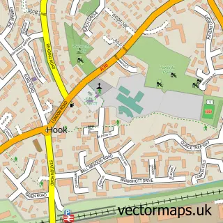
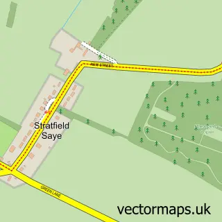
This Sherfield on Loddon street map is a detailed vector street map covering a 750m x 750m area. Select a larger area to create and download your own vector street map of Sherfield on Loddon.
The 750-metre map sample for Sherfield on Loddon covers 349 mapped buildings and approximately 17.8 km of road detail, of which 22 named roads are named. The immediate area includes 1 GP surgery within 2 miles, 2 pubs and 1 MOT station, with 3 within 2 miles. The wider area around Sherfield on Loddon features 3 food and drink venues. To create a larger or custom map of Sherfield on Loddon, the map builder lets you define your own coverage area and download editable SVG, PDF and PNG files.
Create a larger editable map of Sherfield on Loddon
Choose any area you need and generate a high-quality vector map instantly. Perfect for print, planning, design, business and personal use.

This Sherfield on Loddon street map in Hampshire is available as downloadable SVG, PDF and PNG map files, or as a printed map for planning, business, display, education, local information and design work. You can also create a larger custom map area using the map selector.
What this Sherfield on Loddon map sample shows
Sherfield on Loddon lies within Sherfield On Loddon Cp parish, part of Bramley And Sherfield ward in the Basingstoke And Deane District (B) local authority area. The postcode geography for this area includes the RG postcode area, the RG27 postcode district and the RG27 0 postcode sector. Residents fall under the Nhs Hampshire And Isle Of Wight Integrated Care Board for NHS services.
Local features near Sherfield on Loddon
Within 2 milesAmenities and services in and around Sherfield on Loddon.
Administrative and postcode information for Sherfield on Loddon
Sherfield on Loddon lies within Sherfield On Loddon Cp parish, part of Bramley And Sherfield ward in the Basingstoke And Deane District (B) local authority area. The postcode geography for this area includes the RG postcode area, the RG27 postcode district and the RG27 0 postcode sector. Residents fall under the Nhs Hampshire And Isle Of Wight Integrated Care Board for NHS services.
Nearby street map samples around Sherfield on Loddon


More street maps in Hampshire
750 metre map area coverage
Boundary, postcode and point of interest information for the 750m x 750m rectangle centred on this sample map.
Boundaries containing map centre
Constituency: North East Hampshire Co Const
County: Hampshire County
District: Basingstoke and Deane District (B)
Icb: NHS Hampshire and Isle of Wight ICB
Parish: Sherfield on Loddon CP
Police Force: hampshire
Postcode District: RG27
Postcode Sector: RG27 0
Ward: Bramley Ward
Nearby boundaries intersecting sample
Parish: Bramley CP, Hartley Wespall CP
Postcode District: RG26
Postcode Sector: RG26 5
Postcode coverage
POI category counts
Building Supply Store: 2
Plumbing: 2
Pub: 2
Web Designer: 2
Appliance Store: 1
Automotive Repair: 1
Beauty Salon: 1
Brewery: 1
British Restaurant: 1
Bus Station: 1
Sample points of interest
- Acorn Services
- The Garage At Sherfield
- The Salon Sherfield
- Sherfield Village Brewery
- The Coffee Shop
- Fyne Flooring
- Harman Oliver
- Post Office
- The Coffee Shop
- Sherfield-on-Loddon Village Hall
- Londis
- The Giles Practice
Create a larger editable map of Sherfield on Loddon
This sample shows only a 750 metre area. To create a larger map of Sherfield on Loddon, use our map builder to choose your own coverage area, add titles and download editable SVG, PDF and PNG files.
Create a custom map of Sherfield on Loddon