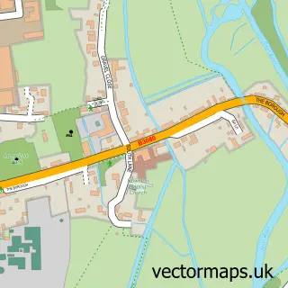
This Breamore street map is a detailed vector street map covering a 750m x 750m area. Select a larger area to create and download your own vector street map of Breamore.
The 750-metre map sample for Breamore covers 76 mapped buildings and approximately 7.1 km of road detail, of which 2 named roads are named. The immediate area includes 1 school and 3 pubs. The wider area around Breamore features 3 food and drink venues. To create a larger or custom map of Breamore, the map builder lets you define your own coverage area and download editable SVG, PDF and PNG files.
Create a larger editable map of Breamore
Choose any area you need and generate a high-quality vector map instantly. Perfect for print, planning, design, business and personal use.

This Breamore street map in Hampshire is available as downloadable SVG, PDF and PNG map files, or as a printed map for planning, business, display, education, local information and design work. You can also create a larger custom map area using the map selector.
What this Breamore map sample shows
Breamore lies within Breamore Cp parish, part of Downlands And Forest ward in the New Forest District local authority area. The postcode geography for this area includes the SP postcode area, the SP6 postcode district and the SP6 2 postcode sector. Residents fall under the Nhs Hampshire And Isle Of Wight Integrated Care Board for NHS services.
Local features near Breamore
Within 2 milesAmenities and services in and around Breamore.
Administrative and postcode information for Breamore
Breamore lies within Breamore Cp parish, part of Downlands And Forest ward in the New Forest District local authority area. The postcode geography for this area includes the SP postcode area, the SP6 postcode district and the SP6 2 postcode sector. Residents fall under the Nhs Hampshire And Isle Of Wight Integrated Care Board for NHS services.
Nearby street map samples around Breamore


More street maps in Hampshire
750 metre map area coverage
Boundary, postcode and point of interest information for the 750m x 750m rectangle centred on this sample map.
Boundaries containing map centre
Constituency: New Forest West Co Const
County: Hampshire County
District: New Forest District
Icb: NHS Hampshire and Isle of Wight ICB
Parish: Breamore CP
Police Force: hampshire
Postcode District: SP6
Postcode Sector: SP6 2
Ward: Downlands & Forest North Ward
Nearby boundaries intersecting sample
No additional intersecting boundaries found.
Postcode coverage
POI category counts
Pub: 3
Elementary School: 2
Bridal Shop: 1
Building Supply Store: 1
Community Center: 1
Home Goods Store: 1
Religious Organization: 1
Train Station: 1
Sample points of interest
- Joanna Bell
- David Cutler Associates
- Hulse Hall
- Breamore C of E Controlled Primary School
- Hampshire County Council
- The Old Pine Stores
- Bat & Ball
- Bat and Ball
- The Bat and Ball
- Messy Church at Breamore
- Breamore railway station
Create a larger editable map of Breamore
This sample shows only a 750 metre area. To create a larger map of Breamore, use our map builder to choose your own coverage area, add titles and download editable SVG, PDF and PNG files.
Create a custom map of Breamore