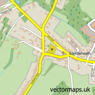
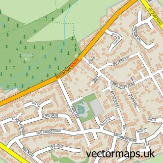
This Fordingbridge street map is a detailed vector street map covering a 750m x 750m area. Select a larger area to create and download your own vector street map of Fordingbridge.
The 750-metre map sample for Fordingbridge covers 363 mapped buildings and approximately 16.9 km of road detail, of which 36 named roads are named. The immediate area includes 1 GP surgery, 3 pubs and 3 MOT stations within 2 miles. The wider area around Fordingbridge features 3 tourism points of interest, 9 food and drink venues and 1 hotel. To create a larger or custom map of Fordingbridge, the map builder lets you define your own coverage area and download editable SVG, PDF and PNG files.
Create a larger editable map of Fordingbridge
Choose any area you need and generate a high-quality vector map instantly. Perfect for print, planning, design, business and personal use.

This Fordingbridge street map in Hampshire is available as downloadable SVG, PDF and PNG map files, or as a printed map for planning, business, display, education, local information and design work. You can also create a larger custom map area using the map selector.
What this Fordingbridge map sample shows
Fordingbridge lies within Fordingbridge Cp parish, part of Fordingbridge ward in the New Forest District local authority area. The postcode geography for this area includes the SP postcode area, the SP6 postcode district and the SP6 1 postcode sector. Residents fall under the Nhs Hampshire And Isle Of Wight Integrated Care Board for NHS services.
Local features near Fordingbridge
Within 2 milesAmenities and services in and around Fordingbridge.
Administrative and postcode information for Fordingbridge
The local authority covering Fordingbridge is New Forest District, within the county of Hampshire. The settlement lies within Fordingbridge ward and Fordingbridge Cp civil parish. The SP6 postcode district and SP6 1 postcode sector serve the immediate area. NHS provision in the area is delivered through Salisbury Nhs Foundation Trust.
Nearby street map samples around Fordingbridge


More street maps in Hampshire
750 metre map area coverage
Boundary, postcode and point of interest information for the 750m x 750m rectangle centred on this sample map.
Boundaries containing map centre
Constituency: New Forest West Co Const
County: Hampshire County
District: New Forest District
Icb: NHS Hampshire and Isle of Wight ICB
Parish: Fordingbridge CP
Police Force: hampshire
Postcode District: SP6
Postcode Sector: SP6 1
Ward: Fordingbridge, Godshill & Hyde Ward
Nearby boundaries intersecting sample
Postcode Sector: SP6 2
Postcode coverage
POI category counts
Real Estate Agent: 7
Beauty Salon: 5
Cafe: 5
Flowers And Gifts Shop: 5
Hair Salon: 5
Barber: 4
Building Supply Store: 4
Church Cathedral: 4
Gift Shop: 4
Toy Store: 4
Sample points of interest
- Telemarketing Service Solutions
- St Mary the Virgin, Fordingbridge
- C&D Fine Art
- Fordingbridge Entertainments Society
- Cognatum
- Green Lane House
- The English Courtyard Association
- The Cooperative Food (BF) Fordingbridge (ERF)
- Dan Walters
- S & B Motors
- Belindas Bakery
- Cake Art Collective
Create a larger editable map of Fordingbridge
This sample shows only a 750 metre area. To create a larger map of Fordingbridge, use our map builder to choose your own coverage area, add titles and download editable SVG, PDF and PNG files.
Create a custom map of Fordingbridge