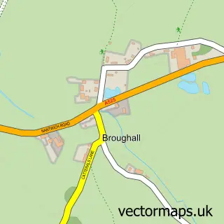
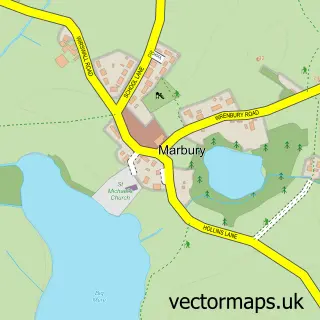
This Burleydam street map is a detailed vector street map covering a 750m x 750m area. Select a larger area to create and download your own vector street map of Burleydam.
The 750-metre map sample for Burleydam covers 56 mapped buildings and approximately 4.4 km of road detail, of which 2 named roads are named. The immediate area includes 2 pubs. The wider area around Burleydam features 2 food and drink venues. To create a larger or custom map of Burleydam, the map builder lets you define your own coverage area and download editable SVG, PDF and PNG files.
Create a larger editable map of Burleydam
Choose any area you need and generate a high-quality vector map instantly. Perfect for print, planning, design, business and personal use.

This Burleydam street map in Cheshire is available as downloadable SVG, PDF and PNG map files, or as a printed map for planning, business, display, education, local information and design work. You can also create a larger custom map area using the map selector.
What this Burleydam map sample shows
Burleydam lies within Dodcott Cum Wilkesley Cp parish, part of Audlem ward in the Cheshire East (B) local authority area. The postcode geography for this area includes the SY postcode area, the SY13 postcode district and the SY13 4 postcode sector. Residents fall under the Nhs Cheshire And Merseyside Integrated Care Board for NHS services.
Local features near Burleydam
Within 2 milesAmenities and services in and around Burleydam.
Administrative and postcode information for Burleydam
The local authority covering Burleydam is Cheshire East (B), within the county of Cheshire. The settlement lies within Audlem ward and Dodcott Cum Wilkesley Cp civil parish. The SY13 postcode district and SY13 4 postcode sector serve the immediate area. NHS provision in the area is delivered through Mid Cheshire Hospitals Nhs Foundation Trust.
Nearby street map samples around Burleydam

More street maps in Cheshire
750 metre map area coverage
Boundary, postcode and point of interest information for the 750m x 750m rectangle centred on this sample map.
Boundaries containing map centre
Constituency: Chester South and Eddisbury Co Const
District: Cheshire East (B)
Icb: NHS Cheshire and Merseyside ICB
Parish: Dodcott cum Wilkesley CP
Police Force: cheshire
Postcode District: SY13
Postcode Sector: SY13 4
Ward: Audlem Ward
Nearby boundaries intersecting sample
No additional intersecting boundaries found.
Postcode coverage
POI category counts
Dance School: 2
Pub: 2
Anglican Church: 1
Church Cathedral: 1
Professional Services: 1
Sample points of interest
- St Mary and St Michael
- St Mary's and St Michael's Church
- Pritchards Dance & Fitness Academy
- Pritchards Dance & Fitness Academy
- Nigel Standley Associates
- The Combermere Arms
- The Combermere Arms
Create a larger editable map of Burleydam
This sample shows only a 750 metre area. To create a larger map of Burleydam, use our map builder to choose your own coverage area, add titles and download editable SVG, PDF and PNG files.
Create a custom map of Burleydam