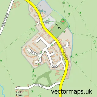
This Cambridge street map is a detailed vector street map covering a 750m x 750m area. Select a larger area to create and download your own vector street map of Cambridge.
The 750-metre map sample for Cambridge covers 117 mapped buildings and approximately 20.8 km of road detail, of which 4 named roads are named. The immediate area includes 1 pub and 5 MOT stations within 2 miles. The wider area around Cambridge features 1 food and drink venue, 1 hotel and 1 campsite within 2 miles. To create a larger or custom map of Cambridge, the map builder lets you define your own coverage area and download editable SVG, PDF and PNG files.
Create a larger editable map of Cambridge
Choose any area you need and generate a high-quality vector map instantly. Perfect for print, planning, design, business and personal use.

This Cambridge street map in Gloucestershire is available as downloadable SVG, PDF and PNG map files, or as a printed map for planning, business, display, education, local information and design work. You can also create a larger custom map area using the map selector.
What this Cambridge map sample shows
Cambridge lies within Slimbridge Cp parish, part of Berkeley Vale ward in the Stroud District local authority area. The postcode geography for this area includes the GL postcode area, the GL2 postcode district and the GL2 7 postcode sector. Residents fall under the Nhs Gloucestershire Integrated Care Board for NHS services.
Local features near Cambridge
Within 2 milesAmenities and services in and around Cambridge.
Administrative and postcode information for Cambridge
The local authority covering Cambridge is Stroud District, within the county of Gloucestershire. The settlement lies within Berkeley Vale ward and Slimbridge Cp civil parish. The GL2 postcode district and GL2 7 postcode sector serve the immediate area. NHS provision in the area is delivered through Gloucestershire Hospitals Nhs Foundation Trust.
Nearby street map samples around Cambridge


More street maps in Gloucestershire
750 metre map area coverage
Boundary, postcode and point of interest information for the 750m x 750m rectangle centred on this sample map.
Boundaries containing map centre
Constituency: Stroud Co Const
County: Gloucestershire County
District: Stroud District
Icb: NHS Gloucestershire ICB
Parish: Slimbridge CP
Police Force: gloucestershire
Postcode District: GL2
Postcode Sector: GL2 7
Ward: Berkeley Vale Ward
Nearby boundaries intersecting sample
Parish: Coaley CP
Ward: Coaley & Uley Ward
Postcode coverage
POI category counts
Carpet Store: 4
Anesthesiologist: 1
Automotive Repair: 1
Bar: 1
Car Dealer: 1
Carpenter: 1
Clothing Store: 1
Construction Services: 1
Cooking School: 1
Engine Repair Service: 1
Sample points of interest
- Cavendish Clinic
- Tony Weston
- Marston'S Estates
- Mobility Disabled
- Caesarcraft
- Chris Groome
- Cotswold Carpets Direct
- Cotswold Wholesale Flooring
- Natura Wood Floors
- The Edinburgh Woollen Mill
- Building Restorations Ltd
- Severn Bites Breadmaking Classes
Create a larger editable map of Cambridge
This sample shows only a 750 metre area. To create a larger map of Cambridge, use our map builder to choose your own coverage area, add titles and download editable SVG, PDF and PNG files.
Create a custom map of Cambridge