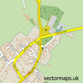
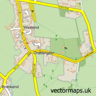
This Churchill street map is a detailed vector street map covering a 750m x 750m area. Select a larger area to create and download your own vector street map of Churchill.
The 750-metre map sample for Churchill covers 199 mapped buildings and approximately 28.1 km of road detail, of which 12 named roads are named. The immediate area includes 1 pub and 1 MOT station. The wider area around Churchill features 1 tourism point of interest, 1 food and drink venue and 1 hotel. To create a larger or custom map of Churchill, the map builder lets you define your own coverage area and download editable SVG, PDF and PNG files.
Create a larger editable map of Churchill
Choose any area you need and generate a high-quality vector map instantly. Perfect for print, planning, design, business and personal use.

This Churchill street map in Oxfordshire is available as downloadable SVG, PDF and PNG map files, or as a printed map for planning, business, display, education, local information and design work. You can also create a larger custom map area using the map selector.
What this Churchill map sample shows
Churchill lies within Churchill Cp parish, part of Chadlington And Churchill ward in the West Oxfordshire District local authority area. The postcode geography for this area includes the OX postcode area, the OX7 postcode district and the OX7 6 postcode sector. Residents fall under the Nhs Buckinghamshire, Oxfordshire And Berkshire West Integrated Care Board for NHS services.
Local features near Churchill
Within 2 milesAmenities and services in and around Churchill.
Administrative and postcode information for Churchill
The local authority covering Churchill is West Oxfordshire District, within the county of Oxfordshire. The settlement lies within Chadlington And Churchill ward and Churchill Cp civil parish. The OX7 postcode district and OX7 6 postcode sector serve the immediate area. NHS provision in the area is delivered through Oxford University Hospitals Nhs Foundation Trust.
Nearby street map samples around Churchill

More street maps in Oxfordshire
750 metre map area coverage
Boundary, postcode and point of interest information for the 750m x 750m rectangle centred on this sample map.
Boundaries containing map centre
Constituency: Banbury Co Const
County: Oxfordshire County
District: West Oxfordshire District
Icb: NHS Thames Valley ICB
Parish: Churchill CP
Police Force: thames valley
Postcode District: OX7
Postcode Sector: OX7 6
Ward: Chadlington and Churchill Ward
Nearby boundaries intersecting sample
No additional intersecting boundaries found.
Postcode coverage
POI category counts
Anglican Church: 2
Event Technology Service: 2
Post Office: 2
Amusement Park: 1
Automotive Repair: 1
Bed And Breakfast: 1
Cabin: 1
Church Cathedral: 1
Fashion: 1
Hotel: 1
Sample points of interest
- Equinethos
- All Saints Church
- Churchill, Churchill All Saints
- The Forge Garage, Churchill
- The Forge Bed and Breakfast
- Hackers End
- Churchill Village Green
- Eclectic Events
- Pedal Car Parties
- Archivist Gallery
- Corner House at Churchill
- Door 2 Door Pet Supplies
Create a larger editable map of Churchill
This sample shows only a 750 metre area. To create a larger map of Churchill, use our map builder to choose your own coverage area, add titles and download editable SVG, PDF and PNG files.
Create a custom map of Churchill