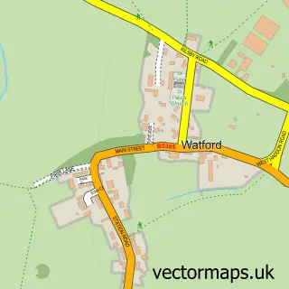
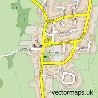
This Crick street map is a detailed vector street map covering a 750m x 750m area. Select a larger area to create and download your own vector street map of Crick.
The 750-metre map sample for Crick covers 512 mapped buildings and approximately 30.4 km of road detail, of which 34 named roads are named. The immediate area includes 1 school, 1 GP surgery within 2 miles, 5 pubs and 1 MOT station within 2 miles. The wider area around Crick features 6 food and drink venues. To create a larger or custom map of Crick, the map builder lets you define your own coverage area and download editable SVG, PDF and PNG files.
Create a larger editable map of Crick
Choose any area you need and generate a high-quality vector map instantly. Perfect for print, planning, design, business and personal use.

This Crick street map in Northamptonshire is available as downloadable SVG, PDF and PNG map files, or as a printed map for planning, business, display, education, local information and design work. You can also create a larger custom map area using the map selector.
What this Crick map sample shows
Crick lies within Crick Cp parish, part of Barby And Kilsby ward in the West Northamptonshire local authority area. The postcode geography for this area includes the NN postcode area, the NN6 postcode district and the NN6 7 postcode sector. Residents fall under the Nhs Northamptonshire Integrated Care Board for NHS services.
Local features near Crick
Within 2 milesAmenities and services in and around Crick.
Administrative and postcode information for Crick
The local authority covering Crick is West Northamptonshire, within the county of Northamptonshire. The settlement lies within Barby And Kilsby ward and Crick Cp civil parish. The NN6 postcode district and NN6 7 postcode sector serve the immediate area. NHS provision in the area is delivered through University Hospitals Coventry And Warwickshire Nhs Trust.
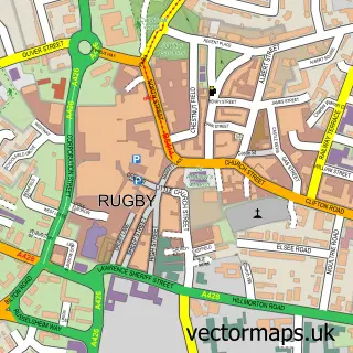
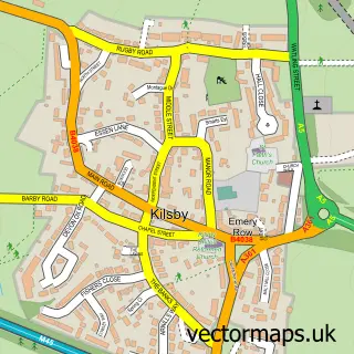
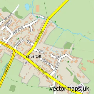
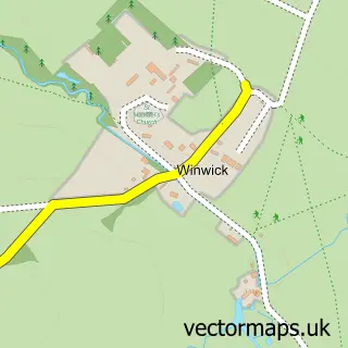
Nearby street map samples around Crick

More street maps in Northamptonshire
750 metre map area coverage
Boundary, postcode and point of interest information for the 750m x 750m rectangle centred on this sample map.
Boundaries containing map centre
Constituency: Daventry Co Const
District: West Northamptonshire
Icb: NHS Northamptonshire ICB
Parish: Crick CP
Police Force: northamptonshire
Postcode District: NN6
Postcode Sector: NN6 7
Ward: Braunston & Crick Ward
Nearby boundaries intersecting sample
No additional intersecting boundaries found.
Postcode coverage
POI category counts
Pub: 5
Grocery Store: 2
Indian Restaurant: 2
Newspaper And Magazines Store: 2
Scout Hall: 2
Anglican Church: 1
Art Gallery: 1
Atms: 1
Baby Gear And Furniture: 1
Bar: 1
Sample points of interest
- St. Margaret of Antioch Church, Crick
- A&A at No.7
- Heart of England Co-operative Crick
- Daisy Dumpling
- Crick Music Festival
- Serenity Skin & Beauty
- Bee Beautiful
- Low Thatch Cottage Bed & Breakfast
- Grove Roofing
- Pickle & Pie At 23
- Towers And Son funeral services
- Post Office Travel Money
Create a larger editable map of Crick
This sample shows only a 750 metre area. To create a larger map of Crick, use our map builder to choose your own coverage area, add titles and download editable SVG, PDF and PNG files.
Create a custom map of Crick