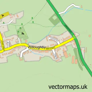
This Kilsby street map is a detailed vector street map covering a 750m x 750m area. Select a larger area to create and download your own vector street map of Kilsby.
The 750-metre map sample for Kilsby covers 359 mapped buildings and approximately 33.8 km of road detail, of which 28 named roads are named. The immediate area includes 1 school, 1 GP surgery within 2 miles, 2 pubs and 1 MOT station within 2 miles. The wider area around Kilsby features 2 food and drink venues and 2 hotels. To create a larger or custom map of Kilsby, the map builder lets you define your own coverage area and download editable SVG, PDF and PNG files.
Create a larger editable map of Kilsby
Choose any area you need and generate a high-quality vector map instantly. Perfect for print, planning, design, business and personal use.

This Kilsby street map in Northamptonshire is available as downloadable SVG, PDF and PNG map files, or as a printed map for planning, business, display, education, local information and design work. You can also create a larger custom map area using the map selector.
What this Kilsby map sample shows
Kilsby lies within Kilsby Cp parish, part of Barby And Kilsby ward in the West Northamptonshire local authority area. The postcode geography for this area includes the CV postcode area, the CV23 postcode district and the CV23 8 postcode sector. Residents fall under the Nhs Northamptonshire Integrated Care Board for NHS services.
Local features near Kilsby
Within 2 milesAmenities and services in and around Kilsby.
Administrative and postcode information for Kilsby
Kilsby lies within Kilsby Cp parish, part of Barby And Kilsby ward in the West Northamptonshire local authority area. The postcode geography for this area includes the CV postcode area, the CV23 postcode district and the CV23 8 postcode sector. Residents fall under the Nhs Northamptonshire Integrated Care Board for NHS services.
Nearby street map samples around Kilsby

More street maps in Northamptonshire
750 metre map area coverage
Boundary, postcode and point of interest information for the 750m x 750m rectangle centred on this sample map.
Boundaries containing map centre
Constituency: Daventry Co Const
District: West Northamptonshire
Icb: NHS Northamptonshire ICB
Parish: Kilsby CP
Police Force: northamptonshire
Postcode District: CV23
Postcode Sector: CV23 8
Ward: Braunston & Crick Ward
Nearby boundaries intersecting sample
No additional intersecting boundaries found.
Postcode coverage
POI category counts
Automotive Repair: 2
Building Supply Store: 2
Church Cathedral: 2
Hotel: 2
It Service And Computer Repair: 2
Preschool: 2
Pub: 2
Shipping Center: 2
Anglican Church: 1
Animal Shelter: 1
Sample points of interest
- St Faith's, Kilsby
- Kilsby Cattery
- J Coates
- Lasalign
- Kean Dale Professional Nails
- Hunt House Quarters
- Middlemarch Construction Ltd.
- Dave Hyam Cleaning Services
- Skipy Skip Hire
- Dave Hyam Carpet Cleaning
- Kilsby URC Church
- St Faith's Church
Create a larger editable map of Kilsby
This sample shows only a 750 metre area. To create a larger map of Kilsby, use our map builder to choose your own coverage area, add titles and download editable SVG, PDF and PNG files.
Create a custom map of Kilsby