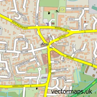
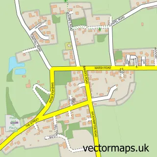
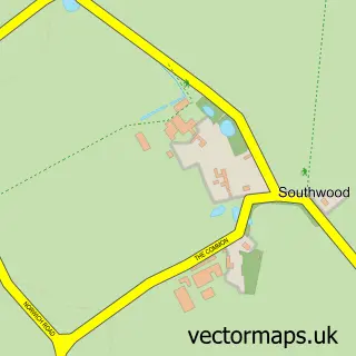
This Damgate street map is a detailed vector street map covering a 750m x 750m area. Select a larger area to create and download your own vector street map of Damgate.
The 750-metre map sample for Damgate covers 205 mapped buildings and approximately 12.9 km of road detail, of which 11 named roads are named. The immediate area includes 1 GP surgery within 2 miles and 1 MOT station. The wider area around Damgate features 1 campsite within 2 miles. To create a larger or custom map of Damgate, the map builder lets you define your own coverage area and download editable SVG, PDF and PNG files.
Create a larger editable map of Damgate
Choose any area you need and generate a high-quality vector map instantly. Perfect for print, planning, design, business and personal use.

This Damgate street map in Norfolk is available as downloadable SVG, PDF and PNG map files, or as a printed map for planning, business, display, education, local information and design work. You can also create a larger custom map area using the map selector.
What this Damgate map sample shows
Damgate lies within Acle Cp parish, part of Acle ward in the Broadland District local authority area. The postcode geography for this area includes the NR postcode area, the NR13 postcode district and the NR13 3 postcode sector. Residents fall under the Nhs Norfolk And Waveney Integrated Care Board for NHS services.
Local features near Damgate
Within 2 milesAmenities and services in and around Damgate.
Administrative and postcode information for Damgate
The local authority covering Damgate is Broadland District, within the county of Norfolk. The settlement lies within Acle ward and Acle Cp civil parish. The NR13 postcode district and NR13 3 postcode sector serve the immediate area. NHS provision in the area is delivered through Norfolk And Norwich University Hospitals Nhs Foundation Trust.
Nearby street map samples around Damgate

More street maps in Norfolk
750 metre map area coverage
Boundary, postcode and point of interest information for the 750m x 750m rectangle centred on this sample map.
Boundaries containing map centre
Constituency: Broadland and Fakenham Co Const
County: Norfolk County
District: Broadland District
Icb: NHS Norfolk and Waveney ICB
Parish: Acle CP
Police Force: norfolk
Postcode District: NR13
Postcode Sector: NR13 3
Ward: Acle Ward
Nearby boundaries intersecting sample
No additional intersecting boundaries found.
Postcode coverage
POI category counts
Auction House: 2
Auto Company: 2
Building Supply Store: 2
Motorcycle Dealer: 2
Business To Business: 1
Car Rental Agency: 1
Clothing Store: 1
Community Center: 1
Courier And Delivery Services: 1
Engineering Services: 1
Sample points of interest
- Horners Auctioneers
- Horners Auctioneers
- Acle Motor Company
- SP AUTO Car-Sales
- Redo Kitchens
- Rhino Building & Diy Supplies Ltd
- RDM CNC Ltd.
- Acle A's Classic VW Campervan Hire
- LBF Trade
- High Grade House
- Evri ParcelShop
- Tudor Printing
Create a larger editable map of Damgate
This sample shows only a 750 metre area. To create a larger map of Damgate, use our map builder to choose your own coverage area, add titles and download editable SVG, PDF and PNG files.
Create a custom map of Damgate