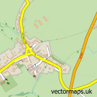
This East Cowton street map is a detailed vector street map covering a 750m x 750m area. Select a larger area to create and download your own vector street map of East Cowton.
The 750-metre map sample for East Cowton covers 174 mapped buildings and approximately 10.0 km of road detail, of which 7 named roads are named. The immediate area includes 1 school, 2 pubs and 1 MOT station within 2 miles. The wider area around East Cowton features 3 food and drink venues. To create a larger or custom map of East Cowton, the map builder lets you define your own coverage area and download editable SVG, PDF and PNG files.
Create a larger editable map of East Cowton
Choose any area you need and generate a high-quality vector map instantly. Perfect for print, planning, design, business and personal use.

This East Cowton street map in North Yorkshire is available as downloadable SVG, PDF and PNG map files, or as a printed map for planning, business, display, education, local information and design work. You can also create a larger custom map area using the map selector.
What this East Cowton map sample shows
East Cowton lies within East Cowton Cp parish, part of Appleton Wiske & Smeatons ward in the North Yorkshire local authority area. The postcode geography for this area includes the DL postcode area, the DL7 postcode district and the DL7 0 postcode sector. Residents fall under the Nhs Humber And North Yorkshire Integrated Care Board for NHS services.
Local features near East Cowton
Within 2 milesAmenities and services in and around East Cowton.
Administrative and postcode information for East Cowton
East Cowton lies within East Cowton Cp parish, part of Appleton Wiske & Smeatons ward in the North Yorkshire local authority area. The postcode geography for this area includes the DL postcode area, the DL7 postcode district and the DL7 0 postcode sector. Residents fall under the Nhs Humber And North Yorkshire Integrated Care Board for NHS services.
Nearby street map samples around East Cowton


More street maps in North Yorkshire
750 metre map area coverage
Boundary, postcode and point of interest information for the 750m x 750m rectangle centred on this sample map.
Boundaries containing map centre
Constituency: Richmond and Northallerton Co Const
District: North Yorkshire
Icb: NHS Humber and North Yorkshire ICB
Parish: East Cowton CP
Police Force: north yorkshire
Postcode District: DL7
Postcode Sector: DL7 0
Nearby boundaries intersecting sample
No additional intersecting boundaries found.
Postcode coverage
POI category counts
Elementary School: 2
Pub: 2
Shipping Center: 2
Anglican Church: 1
Building Supply Store: 1
Community Services Non Profits: 1
Contractor: 1
Cricket Ground: 1
It Service And Computer Repair: 1
Photography Store And Services: 1
Sample points of interest
- East Cowton: All Saints
- Chris Grant Tiling
- East Cowton New Village Hall Association
- John Sanderson
- East Cowton Cricket Club
- East Cowton Church of England Primary School
- East Cowton Primary School
- Kylua
- Tim Stewart Photography
- Bees Wing Inn East Cownton
- The Beeswing Inn
- Beeswing Pub
Create a larger editable map of East Cowton
This sample shows only a 750 metre area. To create a larger map of East Cowton, use our map builder to choose your own coverage area, add titles and download editable SVG, PDF and PNG files.
Create a custom map of East Cowton