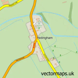
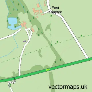
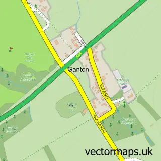
This East Heslerton street map is a detailed vector street map covering a 750m x 750m area. Select a larger area to create and download your own vector street map of East Heslerton.
The 750-metre map sample for East Heslerton covers 75 mapped buildings and approximately 5.9 km of road detail, of which 2 named roads are named. The wider area around East Heslerton features 1 campsite within 2 miles. To create a larger or custom map of East Heslerton, the map builder lets you define your own coverage area and download editable SVG, PDF and PNG files.
Create a larger editable map of East Heslerton
Choose any area you need and generate a high-quality vector map instantly. Perfect for print, planning, design, business and personal use.

This East Heslerton street map in North Yorkshire is available as downloadable SVG, PDF and PNG map files, or as a printed map for planning, business, display, education, local information and design work. You can also create a larger custom map area using the map selector.
What this East Heslerton map sample shows
East Heslerton lies within Heslerton Cp parish, part of Sherburn ward in the North Yorkshire local authority area. The postcode geography for this area includes the YO postcode area, the YO17 postcode district and the YO17 8 postcode sector. Residents fall under the Nhs Humber And North Yorkshire Integrated Care Board for NHS services.
Local features near East Heslerton
Within 2 milesAmenities and services in and around East Heslerton.
Administrative and postcode information for East Heslerton
East Heslerton lies within Heslerton Cp parish, part of Sherburn ward in the North Yorkshire local authority area. The postcode geography for this area includes the YO postcode area, the YO17 postcode district and the YO17 8 postcode sector. Residents fall under the Nhs Humber And North Yorkshire Integrated Care Board for NHS services.
Nearby street map samples around East Heslerton

More street maps in North Yorkshire
750 metre map area coverage
Boundary, postcode and point of interest information for the 750m x 750m rectangle centred on this sample map.
Boundaries containing map centre
Constituency: Thirsk and Malton Co Const
District: North Yorkshire
Icb: NHS Humber and North Yorkshire ICB
Parish: Heslerton CP
Police Force: north yorkshire
Postcode District: YO17
Postcode Sector: YO17 8
Nearby boundaries intersecting sample
No additional intersecting boundaries found.
Postcode coverage
POI category counts
Auto Body Shop: 1
Automotive Repair: 1
Bed And Breakfast: 1
Cabin: 1
Church Cathedral: 1
Gardener: 1
Holiday Rental Home: 1
Horse Trainer: 1
Industrial Equipment: 1
Used Car Dealer: 1
Sample points of interest
- The Dent Specialist
- May's Garage
- Manor Farm Bed and Breakfast
- Lahtlewood Glamping
- St Andrew's Church
- 1st Choice Landscapes
- Yorkshire Homestead
- Ender Racing Stables
- Kridan Forklifts
- Boothby's
Create a larger editable map of East Heslerton
This sample shows only a 750 metre area. To create a larger map of East Heslerton, use our map builder to choose your own coverage area, add titles and download editable SVG, PDF and PNG files.
Create a custom map of East Heslerton