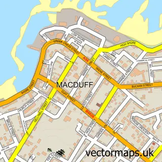
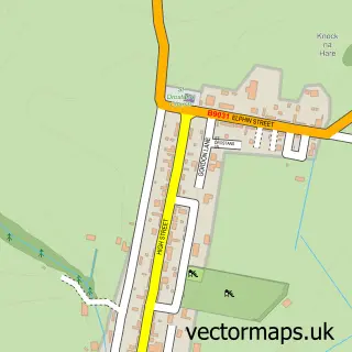
This Gardenstown street map is a detailed vector street map covering a 750m x 750m area. Select a larger area to create and download your own vector street map of Gardenstown.
The 750-metre map sample for Gardenstown covers 188 mapped buildings and approximately 10.5 km of road detail, of which 20 named roads are named. The immediate area includes 1 pub. The wider area around Gardenstown features 2 food and drink venues, 3 hotels and 1 campsite within 2 miles. To create a larger or custom map of Gardenstown, the map builder lets you define your own coverage area and download editable SVG, PDF and PNG files.
Create a larger editable map of Gardenstown
Choose any area you need and generate a high-quality vector map instantly. Perfect for print, planning, design, business and personal use.

This Gardenstown street map in Banffshire is available as downloadable SVG, PDF and PNG map files, or as a printed map for planning, business, display, education, local information and design work. You can also create a larger custom map area using the map selector.
What this Gardenstown map sample shows
Gardenstown lies within Aberdeenshire parish, part of Troup ward in the Aberdeenshire local authority area. Residents fall under the Grampian for NHS services.
Local features near Gardenstown
Within 2 milesAmenities and services in and around Gardenstown.
Administrative and postcode information for Gardenstown
The local authority covering Gardenstown is Aberdeenshire, within the county of Banffshire. The settlement lies within Troup ward and Aberdeenshire civil parish. NHS provision in the area is delivered through Grampian.
Nearby street map samples around Gardenstown

More street maps in Banffshire
750 metre map area coverage
Boundary, postcode and point of interest information for the 750m x 750m rectangle centred on this sample map.
Boundaries containing map centre
Constituency: Aberdeenshire North and Moray East Co Const
District: Aberdeenshire
Icb: Grampian
Postcode District: AB45
Postcode Sector: AB45 3
Ward: Troup Ward
Nearby boundaries intersecting sample
No additional intersecting boundaries found.
Postcode coverage
POI category counts
Cottage: 5
Hotel: 3
Active Life: 2
Beach: 2
Bed And Breakfast: 2
Art Gallery: 1
Bakery: 1
Building Supply Store: 1
Cafe: 1
Church Cathedral: 1
Sample points of interest
- Gamrie Pilates
- Gardenstown Harbour
- New Ground Gallery
- Murray Bros
- Gardenstown Beach
- Gardenstown Beach
- Harbour Cottage - Gardenstown, Scotland
- Kathleen's Bed and Breakfast
- G Burton Plumbing
- Eli's Crafts, Cakes & Coffee
- Gardenstown New Church [Free Church Of Scotland]
- The Little Schoolie
Create a larger editable map of Gardenstown
This sample shows only a 750 metre area. To create a larger map of Gardenstown, use our map builder to choose your own coverage area, add titles and download editable SVG, PDF and PNG files.
Create a custom map of Gardenstown