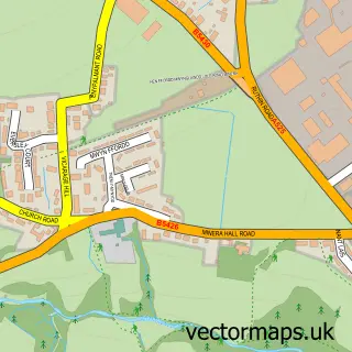
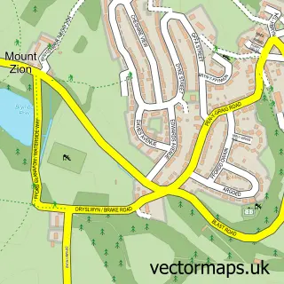
This Gegin street map is a detailed vector street map covering a 750m x 750m area. Select a larger area to create and download your own vector street map of Gegin.
The 750-metre map sample for Gegin covers 107 mapped buildings and approximately 9.4 km of road detail, of which 8 named roads are named. The immediate area includes 1 school, 2 GP surgeries within 2 miles and 1 MOT station, with 4 within 2 miles. To create a larger or custom map of Gegin, the map builder lets you define your own coverage area and download editable SVG, PDF and PNG files.
Create a larger editable map of Gegin
Choose any area you need and generate a high-quality vector map instantly. Perfect for print, planning, design, business and personal use.

This Gegin street map in Clwyd is available as downloadable SVG, PDF and PNG map files, or as a printed map for planning, business, display, education, local information and design work. You can also create a larger custom map area using the map selector.
What this Gegin map sample shows
Gegin lies within Minera Community parish, part of Minera ward in the Wrecsam - Wrexham local authority area. The postcode geography for this area includes the LL postcode area, the LL11 postcode district and the LL11 3 postcode sector. Residents fall under the Betsi Cadwaladr University Health Board for NHS services.
Local features near Gegin
Within 2 milesAmenities and services in and around Gegin.
Administrative and postcode information for Gegin
Gegin lies within Minera Community parish, part of Minera ward in the Wrecsam - Wrexham local authority area. The postcode geography for this area includes the LL postcode area, the LL11 postcode district and the LL11 3 postcode sector. Residents fall under the Betsi Cadwaladr University Health Board for NHS services.
Nearby street map samples around Gegin


More street maps in Clwyd
750 metre map area coverage
Boundary, postcode and point of interest information for the 750m x 750m rectangle centred on this sample map.
Boundaries containing map centre
Constituency: Wrexham Co Const
District: Wrecsam - Wrexham
Icb: Betsi Cadwaladr University
Parish: Minera Community
Police Force: north wales
Postcode District: LL11
Postcode Sector: LL11 3
Nearby boundaries intersecting sample
No additional intersecting boundaries found.
Postcode coverage
POI category counts
Automotive Repair: 4
Building Supply Store: 3
Roofing: 2
Anglican Church: 1
Auto Restoration Services: 1
Bakery: 1
Beauty Salon: 1
Building Contractor: 1
Business: 1
Business Manufacturing And Supply: 1
Sample points of interest
- Saint Mary's Church, Minera, Wrexham
- Spark Automotive
- FAT Dubbers
- HiQ Tyres & Autocare Wrexham
- Minera Tyres & Exhausts Limited
- TD Garage LTD
- Village Bakery
- Bedazzled By Beauty Wrexham
- D & K Home Improvements Ltd.
- Connectec
- Huws Gray Minera
- S & K Mathews
Create a larger editable map of Gegin
This sample shows only a 750 metre area. To create a larger map of Gegin, use our map builder to choose your own coverage area, add titles and download editable SVG, PDF and PNG files.
Create a custom map of Gegin