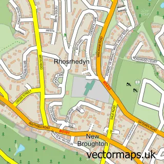
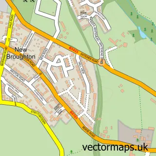
This Southsea street map is a detailed vector street map covering a 750m x 750m area. Select a larger area to create and download your own vector street map of Southsea.
The 750-metre map sample for Southsea covers 204 mapped buildings and approximately 19.6 km of road detail, of which 27 named roads are named. The immediate area includes 1 GP surgery, with 2 within 2 miles, 1 pub and 15 MOT stations within 2 miles. The wider area around Southsea features 2 food and drink venues. To create a larger or custom map of Southsea, the map builder lets you define your own coverage area and download editable SVG, PDF and PNG files.
Create a larger editable map of Southsea
Choose any area you need and generate a high-quality vector map instantly. Perfect for print, planning, design, business and personal use.

This Southsea street map in Clwyd is available as downloadable SVG, PDF and PNG map files, or as a printed map for planning, business, display, education, local information and design work. You can also create a larger custom map area using the map selector.
What this Southsea map sample shows
Southsea lies within Broughton Community parish, part of New Broughton ward in the Wrecsam - Wrexham local authority area. The postcode geography for this area includes the LL postcode area, the LL11 postcode district and the LL11 6 postcode sector. Residents fall under the Betsi Cadwaladr University Health Board for NHS services.
Local features near Southsea
Within 2 milesAmenities and services in and around Southsea.
Administrative and postcode information for Southsea
The local authority covering Southsea is Wrecsam - Wrexham, within the county of Clwyd. The settlement lies within New Broughton ward and Broughton Community civil parish. The LL11 postcode district and LL11 6 postcode sector serve the immediate area. NHS provision in the area is delivered through Betsi Cadwaladr University Health Board.
Nearby street map samples around Southsea


More street maps in Clwyd
750 metre map area coverage
Boundary, postcode and point of interest information for the 750m x 750m rectangle centred on this sample map.
Boundaries containing map centre
Constituency: Wrexham Co Const
District: Wrecsam - Wrexham
Icb: Betsi Cadwaladr University
Parish: Broughton Community
Police Force: north wales
Postcode District: LL11
Postcode Sector: LL11 5
Nearby boundaries intersecting sample
Parish: Brymbo Community
Postcode Sector: LL11 6
Postcode coverage
POI category counts
Beauty Salon: 2
Convenience Store: 2
Hair Salon: 2
Korean Grocery Store: 2
Automotive Repair: 1
Barber: 1
Charity Organization: 1
Church Cathedral: 1
Clothing Store: 1
Contractor: 1
Sample points of interest
- Southsea Garage
- Curt The Barber
- Indulgence salon
- Jordan Mitchell Hairdressing
- Wild Ground
- All Saints Church Southsea
- Run Ragged Wrexham
- Tri-Plan
- AM PM
- Premier Southsea Convenience Store
- North Wales Live
- Forge Road Surgery
Create a larger editable map of Southsea
This sample shows only a 750 metre area. To create a larger map of Southsea, use our map builder to choose your own coverage area, add titles and download editable SVG, PDF and PNG files.
Create a custom map of Southsea