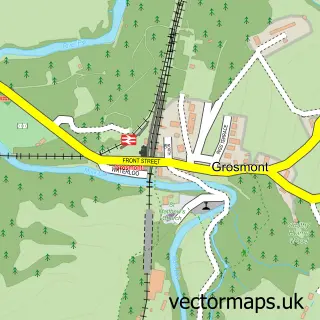
This Glaisdale street map is a detailed vector street map covering a 750m x 750m area. Select a larger area to create and download your own vector street map of Glaisdale.
The 750-metre map sample for Glaisdale covers 143 mapped buildings and approximately 14.2 km of road detail, of which 6 named roads are named. The immediate area includes 1 MOT station within 2 miles. To create a larger or custom map of Glaisdale, the map builder lets you define your own coverage area and download editable SVG, PDF and PNG files.
Create a larger editable map of Glaisdale
Choose any area you need and generate a high-quality vector map instantly. Perfect for print, planning, design, business and personal use.

This Glaisdale street map in North Yorkshire is available as downloadable SVG, PDF and PNG map files, or as a printed map for planning, business, display, education, local information and design work. You can also create a larger custom map area using the map selector.
What this Glaisdale map sample shows
Glaisdale lies within Glaisdale Cp parish, part of Esk Valley ward in the North Yorkshire local authority area. The postcode geography for this area includes the YO postcode area, the YO21 postcode district and the YO21 2 postcode sector. Residents fall under the Nhs Humber And North Yorkshire Integrated Care Board for NHS services.
Local features near Glaisdale
Within 2 milesAmenities and services in and around Glaisdale.
Administrative and postcode information for Glaisdale
Glaisdale lies within Glaisdale Cp parish, part of Esk Valley ward in the North Yorkshire local authority area. The postcode geography for this area includes the YO postcode area, the YO21 postcode district and the YO21 2 postcode sector. Residents fall under the Nhs Humber And North Yorkshire Integrated Care Board for NHS services.
Nearby street map samples around Glaisdale


More street maps in North Yorkshire
750 metre map area coverage
Boundary, postcode and point of interest information for the 750m x 750m rectangle centred on this sample map.
Boundaries containing map centre
Constituency: Scarborough and Whitby Co Const
District: North Yorkshire
Icb: NHS Humber and North Yorkshire ICB
Parish: Glaisdale CP
Police Force: north yorkshire
Postcode District: YO21
Postcode Sector: YO21 2
Nearby boundaries intersecting sample
No additional intersecting boundaries found.
Postcode coverage
POI category counts
Cottage: 2
Shipping Center: 2
Accommodation: 1
Anglican Church: 1
Bed And Breakfast: 1
Bus Station: 1
Butcher Shop: 1
Community Services Non Profits: 1
Furniture Accessory Store: 1
Holiday Rental Home: 1
Sample points of interest
- Laneside Holidays Whitby
- St Thomas Glaisdale
- Arncliffe Arms
- Post Office-Castleton
- Ford Henry Butcher
- The Robinson institute
- Benchmark Cottage
- Ingleside Cottage
- Tbc Joinery And Carpentry
- Arncliffe View
- Neils Halters
- Glaisdale Post Office
Create a larger editable map of Glaisdale
This sample shows only a 750 metre area. To create a larger map of Glaisdale, use our map builder to choose your own coverage area, add titles and download editable SVG, PDF and PNG files.
Create a custom map of Glaisdale