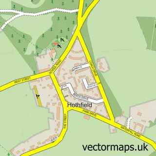
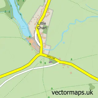
This Great Chart street map is a detailed vector street map covering a 750m x 750m area. Select a larger area to create and download your own vector street map of Great Chart.
The 750-metre map sample for Great Chart covers 253 mapped buildings and approximately 13.4 km of road detail, of which 20 named roads are named. The immediate area includes 1 GP surgery within 2 miles, 1 pub and 13 MOT stations within 2 miles. The wider area around Great Chart features 1 tourism point of interest and 1 food and drink venue. To create a larger or custom map of Great Chart, the map builder lets you define your own coverage area and download editable SVG, PDF and PNG files.
Create a larger editable map of Great Chart
Choose any area you need and generate a high-quality vector map instantly. Perfect for print, planning, design, business and personal use.

This Great Chart street map in Kent is available as downloadable SVG, PDF and PNG map files, or as a printed map for planning, business, display, education, local information and design work. You can also create a larger custom map area using the map selector.
What this Great Chart map sample shows
Great Chart lies within Great Chart With Singleton Cp parish, part of Weald Central ward in the Ashford District (B) local authority area. The postcode geography for this area includes the TN postcode area, the TN23 postcode district and the TN23 3 postcode sector. Residents fall under the Nhs Kent And Medway Integrated Care Board for NHS services.
Local features near Great Chart
Within 2 milesAmenities and services in and around Great Chart.
Administrative and postcode information for Great Chart
The local authority covering Great Chart is Ashford District (B), within the county of Kent. The settlement lies within Weald Central ward and Great Chart With Singleton Cp civil parish. The TN23 postcode district and TN23 3 postcode sector serve the immediate area. NHS provision in the area is delivered through East Kent Hospitals University Nhs Foundation Trust.
Nearby street map samples around Great Chart


More street maps in Kent
750 metre map area coverage
Boundary, postcode and point of interest information for the 750m x 750m rectangle centred on this sample map.
Boundaries containing map centre
Constituency: Weald of Kent Co Const
County: Kent County
District: Ashford District (B)
Icb: NHS Kent and Medway ICB
Parish: Great Chart with Singleton CP
Police Force: kent
Postcode District: TN23
Postcode Sector: TN23 3
Ward: Weald Central Ward
Nearby boundaries intersecting sample
Constituency: Ashford Co Const
Postcode Sector: TN23 5
Ward: Singleton West Ward
Postcode coverage
POI category counts
Church Cathedral: 4
Football Club: 2
Sports Club And League: 2
Anglican Church: 1
Animal Shelter: 1
Bar: 1
Beauty And Spa: 1
Bridal Shop: 1
Building Contractor: 1
Contractor: 1
Sample points of interest
- St Mary's Great Chart
- Courtfield Kennels & Cattery
- The Hoodener's Horse
- Beauty Corner Ashford
- Paul Thomason
- M&m Builders Ashford
- Grace Fellowship
- St Mary C of E Church
- St Mary's Church
- The Grace Fellowship
- Dath Groundworks and Paving
- Avon by Beauty Bosses
Create a larger editable map of Great Chart
This sample shows only a 750 metre area. To create a larger map of Great Chart, use our map builder to choose your own coverage area, add titles and download editable SVG, PDF and PNG files.
Create a custom map of Great Chart