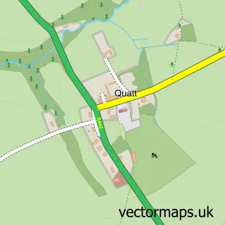
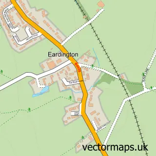
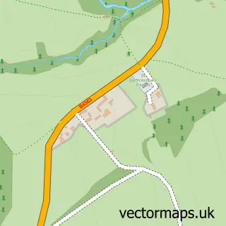
This Hampton Loade street map is a detailed vector street map covering a 750m x 750m area. Select a larger area to create and download your own vector street map of Hampton Loade.
The 750-metre map sample for Hampton Loade covers 82 mapped buildings and approximately 12.0 km of road detail. The immediate area includes 1 railway station, 1 GP surgery within 2 miles and 1 MOT station within 2 miles. The wider area around Hampton Loade features 1 tourism point of interest. To create a larger or custom map of Hampton Loade, the map builder lets you define your own coverage area and download editable SVG, PDF and PNG files.
Create a larger editable map of Hampton Loade
Choose any area you need and generate a high-quality vector map instantly. Perfect for print, planning, design, business and personal use.

This Hampton Loade street map in Shropshire is available as downloadable SVG, PDF and PNG map files, or as a printed map for planning, business, display, education, local information and design work. You can also create a larger custom map area using the map selector.
What this Hampton Loade map sample shows
Hampton Loade lies within Chelmarsh Cp parish, part of Brown Clee ward in the Shropshire local authority area. The postcode geography for this area includes the WV postcode area, the WV16 postcode district and the WV16 6 postcode sector. Residents fall under the Nhs Shropshire, Telford And Wrekin Integrated Care Board for NHS services.
Local features near Hampton Loade
Within 2 milesAmenities and services in and around Hampton Loade.
Administrative and postcode information for Hampton Loade
The local authority covering Hampton Loade is Shropshire, within the county of Shropshire. The settlement lies within Brown Clee ward and Chelmarsh Cp civil parish. The WV16 postcode district and WV16 6 postcode sector serve the immediate area. NHS provision in the area is delivered through The Shrewsbury And Telford Hospital Nhs Trust.
Nearby street map samples around Hampton Loade

More street maps in Shropshire
750 metre map area coverage
Boundary, postcode and point of interest information for the 750m x 750m rectangle centred on this sample map.
Boundaries containing map centre
Constituency: South Shropshire Co Const
District: Shropshire
Icb: NHS Shropshire Telford and Wrekin ICB
Parish: Quatt Malvern CP
Police Force: west mercia
Postcode District: WV15
Postcode Sector: WV15 6
Nearby boundaries intersecting sample
Parish: Alveley CP, Chelmarsh CP
Postcode District: WV16
Postcode Sector: WV16 6
Postcode coverage
POI category counts
Train Station: 3
Bed And Breakfast: 1
Electrician: 1
Hvac Supplier: 1
Park: 1
Parking: 1
Plumbing: 1
Sample points of interest
- Barbel alley B and B
- Mik's Electrical
- Euro Property Maintenance
- Hampton Loade Residential Park
- Hampton Loade B-section Car Park
- Euro Property Maintenance
- Hampton Loade railway station
- Severn Valley Railway
- Severn Valley Railway - Hampton Loade Station
Create a larger editable map of Hampton Loade
This sample shows only a 750 metre area. To create a larger map of Hampton Loade, use our map builder to choose your own coverage area, add titles and download editable SVG, PDF and PNG files.
Create a custom map of Hampton Loade