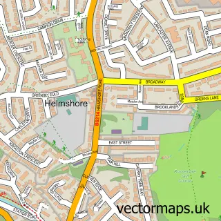
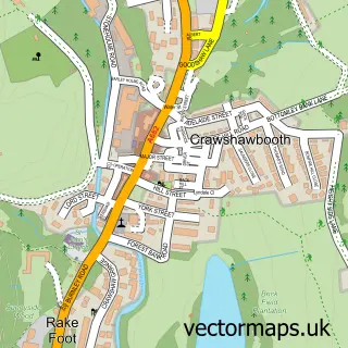
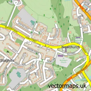
This Haslingden street map is a detailed vector street map covering a 750m x 750m area. Select a larger area to create and download your own vector street map of Haslingden.
The 750-metre map sample for Haslingden covers 299 mapped buildings and approximately 26.9 km of road detail, of which 83 named roads are named. The immediate area includes 2 schools, 3 GP surgeries, with 6 within 2 miles, 4 pubs and 7 MOT stations within 2 miles. The wider area around Haslingden features 1 tourism point of interest and 16 food and drink venues. To create a larger or custom map of Haslingden, the map builder lets you define your own coverage area and download editable SVG, PDF and PNG files.
Create a larger editable map of Haslingden
Choose any area you need and generate a high-quality vector map instantly. Perfect for print, planning, design, business and personal use.

This Haslingden street map in Lancashire is available as downloadable SVG, PDF and PNG map files, or as a printed map for planning, business, display, education, local information and design work. You can also create a larger custom map area using the map selector.
What this Haslingden map sample shows
Haslingden lies within Lancashire County parish, part of Greenfield ward in the Rossendale District (B) local authority area. The postcode geography for this area includes the BB postcode area, the BB4 postcode district and the BB4 6 postcode sector. Residents fall under the Nhs Lancashire And South Cumbria Integrated Care Board for NHS services.
Local features near Haslingden
Within 2 milesAmenities and services in and around Haslingden.
Administrative and postcode information for Haslingden
Haslingden lies within Lancashire County parish, part of Greenfield ward in the Rossendale District (B) local authority area. The postcode geography for this area includes the BB postcode area, the BB4 postcode district and the BB4 6 postcode sector. Residents fall under the Nhs Lancashire And South Cumbria Integrated Care Board for NHS services.
Nearby street map samples around Haslingden

More street maps in Lancashire
750 metre map area coverage
Boundary, postcode and point of interest information for the 750m x 750m rectangle centred on this sample map.
Boundaries containing map centre
Constituency: Hyndburn Co Const
County: Lancashire County
District: Rossendale District (B)
Icb: NHS Lancashire and South Cumbria ICB
Police Force: lancashire
Postcode District: BB4
Postcode Sector: BB4 5
Ward: Haslingden Ward
Nearby boundaries intersecting sample
Postcode Sector: BB4 4, BB4 6
Ward: Greenfield & Eden Ward
Postcode coverage
POI category counts
Beauty Salon: 12
Barber: 7
Charity Organization: 6
Beauty And Spa: 5
Cafe: 5
Clothing Store: 5
Convenience Store: 5
Dentist: 5
Doctor: 5
Fast Food Restaurant: 5
Sample points of interest
- Glenn J Wrighton and Company
- Horrocks & Co.
- Sign It Up
- Sign It Up
- The Office Extra
- Rossendale Antique & Vintage Warehouse
- R & M Heys
- Ming's
- Rosedale Residential Home
- HHH Credit Union
- Haslingden Service Station
- The Cooperative Food (BF) Haslingden, Haslingden
Create a larger editable map of Haslingden
This sample shows only a 750 metre area. To create a larger map of Haslingden, use our map builder to choose your own coverage area, add titles and download editable SVG, PDF and PNG files.
Create a custom map of Haslingden