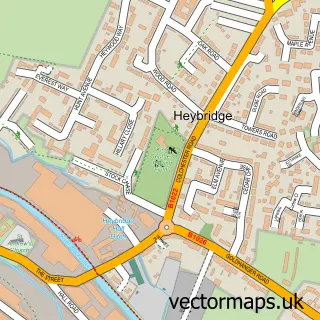
This Heybridge Basin street map is a detailed vector street map covering a 750m x 750m area. Select a larger area to create and download your own vector street map of Heybridge Basin.
The 750-metre map sample for Heybridge Basin covers 252 mapped buildings and approximately 6.1 km of road detail, of which 10 named roads are named. The immediate area includes 2 GP surgeries within 2 miles, 1 pub and 6 MOT stations within 2 miles. The wider area around Heybridge Basin features 3 tourism points of interest, 4 food and drink venues and 1 campsite within 2 miles. To create a larger or custom map of Heybridge Basin, the map builder lets you define your own coverage area and download editable SVG, PDF and PNG files.
Create a larger editable map of Heybridge Basin
Choose any area you need and generate a high-quality vector map instantly. Perfect for print, planning, design, business and personal use.

This Heybridge Basin street map in Essex is available as downloadable SVG, PDF and PNG map files, or as a printed map for planning, business, display, education, local information and design work. You can also create a larger custom map area using the map selector.
What this Heybridge Basin map sample shows
Heybridge Basin lies within Heybridge Basin Cp parish, part of Heybridge East ward in the Maldon District (B) local authority area. The postcode geography for this area includes the CM postcode area, the CM9 postcode district and the CM9 4 postcode sector. Residents fall under the Nhs Mid And South Essex Integrated Care Board for NHS services.
Local features near Heybridge Basin
Within 2 milesAmenities and services in and around Heybridge Basin.
Administrative and postcode information for Heybridge Basin
The local authority covering Heybridge Basin is Maldon District (B), within the county of Essex. The settlement lies within Heybridge East ward and Heybridge Basin Cp civil parish. The CM9 postcode district and CM9 4 postcode sector serve the immediate area. NHS provision in the area is delivered through Mid And South Essex Nhs Foundation Trust.
Nearby street map samples around Heybridge Basin


More street maps in Essex
750 metre map area coverage
Boundary, postcode and point of interest information for the 750m x 750m rectangle centred on this sample map.
Boundaries containing map centre
Constituency: Maldon Co Const
County: Essex County
District: Maldon District (B)
Icb: NHS Essex ICB
Parish: Heybridge Basin CP
Police Force: essex
Postcode District: CM9
Postcode Sector: CM9 4
Ward: Heybridge East Ward
Nearby boundaries intersecting sample
Parish: Heybridge CP, Maldon CP
Ward: Maldon East Ward
Postcode coverage
POI category counts
Anglican Church: 1
Architect: 1
Arts And Entertainment: 1
Attractions And Activities: 1
Boat Parts And Accessories: 1
Boat Rental And Training: 1
Cafe: 1
Coffee Shop: 1
Dog Walkers: 1
Electrician: 1
Sample points of interest
- St George's, Heybridge Basin
- Mark R B Crocker
- Heybridge Basin
- Blackwater River
- Essex Waterways
- Blackwater Sailing Club Wayfarers
- Bargemasters Cabin
- Wilkin & Sons
- Pawz Outdoors
- Longman Electrical Contractors
- Hales Tool & Die Ltd
- The Basin Waterside Market
Create a larger editable map of Heybridge Basin
This sample shows only a 750 metre area. To create a larger map of Heybridge Basin, use our map builder to choose your own coverage area, add titles and download editable SVG, PDF and PNG files.
Create a custom map of Heybridge Basin