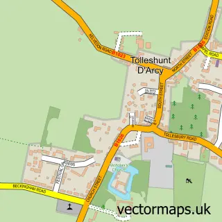
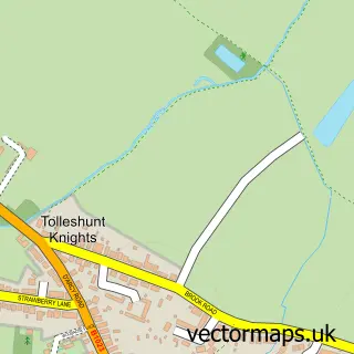
This Tolleshunt Major street map is a detailed vector street map covering a 750m x 750m area. Select a larger area to create and download your own vector street map of Tolleshunt Major.
The 750-metre map sample for Tolleshunt Major covers 128 mapped buildings and approximately 13.3 km of road detail, of which 7 named roads are named. The immediate area includes 1 pub. The wider area around Tolleshunt Major features 2 tourism points of interest and 1 food and drink venue. To create a larger or custom map of Tolleshunt Major, the map builder lets you define your own coverage area and download editable SVG, PDF and PNG files.
Create a larger editable map of Tolleshunt Major
Choose any area you need and generate a high-quality vector map instantly. Perfect for print, planning, design, business and personal use.

This Tolleshunt Major street map in Essex is available as downloadable SVG, PDF and PNG map files, or as a printed map for planning, business, display, education, local information and design work. You can also create a larger custom map area using the map selector.
What this Tolleshunt Major map sample shows
Tolleshunt Major lies within Tolleshunt Major Cp parish, part of Tolleshunt D'arcy ward in the Maldon District (B) local authority area. The postcode geography for this area includes the CM postcode area, the CM9 postcode district and the CM9 8 postcode sector. Residents fall under the Nhs Mid And South Essex Integrated Care Board for NHS services.
Local features near Tolleshunt Major
Within 2 milesAmenities and services in and around Tolleshunt Major.
Administrative and postcode information for Tolleshunt Major
The local authority covering Tolleshunt Major is Maldon District (B), within the county of Essex. The settlement lies within Tolleshunt D'arcy ward and Tolleshunt Major Cp civil parish. The CM9 postcode district and CM9 8 postcode sector serve the immediate area. NHS provision in the area is delivered through East Suffolk And North Essex Nhs Foundation Trust.
Nearby street map samples around Tolleshunt Major


More street maps in Essex
750 metre map area coverage
Boundary, postcode and point of interest information for the 750m x 750m rectangle centred on this sample map.
Boundaries containing map centre
Constituency: Witham Co Const
County: Essex County
District: Maldon District (B)
Icb: NHS Essex ICB
Parish: Tolleshunt Major CP
Police Force: essex
Postcode District: CM9
Postcode Sector: CM9 8
Ward: Tolleshunt D'arcy Ward
Nearby boundaries intersecting sample
No additional intersecting boundaries found.
Postcode coverage
POI category counts
Auto Restoration Services: 2
Car Dealer: 2
Industrial Equipment: 2
Park: 2
Pharmacy: 2
Wholesale Store: 2
Accountant: 1
Auto Electrical Repair: 1
B2b Oil And Gas Extraction And Services: 1
B2b Sporting And Recreation Goods: 1
Sample points of interest
- Baker Clarke
- Polarcool Refrigeration Ltd.
- PT Classics
- Spikes Vintage Restorations
- Essex Gases
- Univerasl Services (sports Equipment) Ltd.
- Bell Inn
- Studio Images
- Reagan Landscapes
- Boston Garage Equipment
- Fieldview Cottage
- Beckingham Garage
Create a larger editable map of Tolleshunt Major
This sample shows only a 750 metre area. To create a larger map of Tolleshunt Major, use our map builder to choose your own coverage area, add titles and download editable SVG, PDF and PNG files.
Create a custom map of Tolleshunt Major