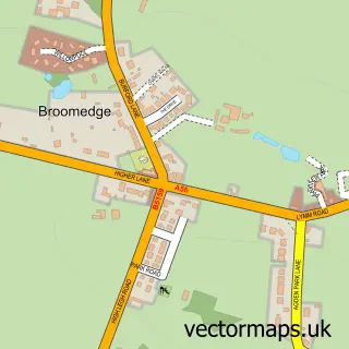
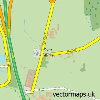
This High Legh street map is a detailed vector street map covering a 750m x 750m area. Select a larger area to create and download your own vector street map of High Legh.
The 750-metre map sample for High Legh covers 294 mapped buildings and approximately 9.9 km of road detail, of which 21 named roads are named. The immediate area includes 1 school and 4 MOT stations within 2 miles. To create a larger or custom map of High Legh, the map builder lets you define your own coverage area and download editable SVG, PDF and PNG files.
Create a larger editable map of High Legh
Choose any area you need and generate a high-quality vector map instantly. Perfect for print, planning, design, business and personal use.

This High Legh street map in Cheshire is available as downloadable SVG, PDF and PNG map files, or as a printed map for planning, business, display, education, local information and design work. You can also create a larger custom map area using the map selector.
What this High Legh map sample shows
High Legh lies within High Legh Cp parish, part of High Legh ward in the Cheshire East (B) local authority area. The postcode geography for this area includes the WA postcode area, the WA16 postcode district and the WA16 6 postcode sector. Residents fall under the Nhs Cheshire And Merseyside Integrated Care Board for NHS services.
Local features near High Legh
Within 2 milesAmenities and services in and around High Legh.
Administrative and postcode information for High Legh
High Legh lies within High Legh Cp parish, part of High Legh ward in the Cheshire East (B) local authority area. The postcode geography for this area includes the WA postcode area, the WA16 postcode district and the WA16 6 postcode sector. Residents fall under the Nhs Cheshire And Merseyside Integrated Care Board for NHS services.
Nearby street map samples around High Legh


More street maps in Cheshire
750 metre map area coverage
Boundary, postcode and point of interest information for the 750m x 750m rectangle centred on this sample map.
Boundaries containing map centre
Constituency: Tatton Co Const
District: Cheshire East (B)
Icb: NHS Cheshire and Merseyside ICB
Parish: High Legh CP
Police Force: cheshire
Postcode District: WA16
Postcode Sector: WA16 6
Ward: High Legh Ward
Nearby boundaries intersecting sample
Postcode Sector: WA16 0
Postcode coverage
POI category counts
Plumbing: 3
Building Supply Store: 2
Legal Services: 2
Accountant: 1
Automotive Repair: 1
Business Consulting: 1
Chemical Plant: 1
Church Cathedral: 1
Clothing Store: 1
Day Care Preschool: 1
Sample points of interest
- Sum It Up Bookkeeping
- Ashley Smithy Motors
- Alan Johnson Plumbing Services
- PLS Remedial Services
- Mesh Associates
- Solstar Europe Ltd
- St Mary's Chapel, High Legh
- CJM Clothing
- High Legh Pre School Nursery
- Walk My K9
- High Legh Primary School
- Green Squirrel Energy Ltd
Create a larger editable map of High Legh
This sample shows only a 750 metre area. To create a larger map of High Legh, use our map builder to choose your own coverage area, add titles and download editable SVG, PDF and PNG files.
Create a custom map of High Legh