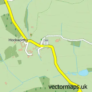
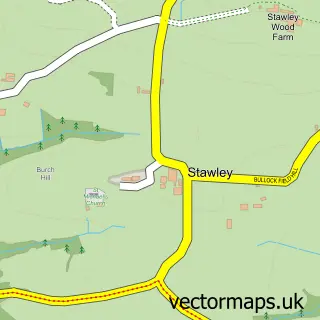
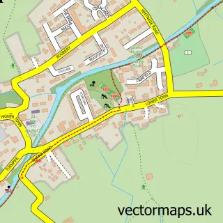
This Holcombe Rogus street map is a detailed vector street map covering a 750m x 750m area. Select a larger area to create and download your own vector street map of Holcombe Rogus.
The 750-metre map sample for Holcombe Rogus covers 123 mapped buildings and approximately 12.7 km of road detail, of which 6 named roads are named. The immediate area includes 1 school, 2 pubs and 1 MOT station, with 2 within 2 miles. The wider area around Holcombe Rogus features 1 tourism point of interest and 2 food and drink venues. To create a larger or custom map of Holcombe Rogus, the map builder lets you define your own coverage area and download editable SVG, PDF and PNG files.
Create a larger editable map of Holcombe Rogus
Choose any area you need and generate a high-quality vector map instantly. Perfect for print, planning, design, business and personal use.

This Holcombe Rogus street map in Devon is available as downloadable SVG, PDF and PNG map files, or as a printed map for planning, business, display, education, local information and design work. You can also create a larger custom map area using the map selector.
What this Holcombe Rogus map sample shows
Holcombe Rogus lies within Holcombe Rogus Cp parish, part of Canonsleigh ward in the Mid Devon District local authority area. The postcode geography for this area includes the TA postcode area, the TA21 postcode district and the TA21 0 postcode sector. Residents fall under the Nhs Devon Integrated Care Board for NHS services.
Local features near Holcombe Rogus
Within 2 milesAmenities and services in and around Holcombe Rogus.
Administrative and postcode information for Holcombe Rogus
The local authority covering Holcombe Rogus is Mid Devon District, within the county of Devon. The settlement lies within Canonsleigh ward and Holcombe Rogus Cp civil parish. The TA21 postcode district and TA21 0 postcode sector serve the immediate area. NHS provision in the area is delivered through Royal Devon University Healthcare Nhs Foundation Trust.
Nearby street map samples around Holcombe Rogus


More street maps in Devon
750 metre map area coverage
Boundary, postcode and point of interest information for the 750m x 750m rectangle centred on this sample map.
Boundaries containing map centre
Constituency: Tiverton and Minehead Co Const
County: Devon County
District: Mid Devon District
Icb: NHS Devon ICB
Parish: Holcombe Rogus CP
Police Force: devon and cornwall
Postcode District: TA21
Postcode Sector: TA21 0
Ward: Canonsleigh Ward
Nearby boundaries intersecting sample
No additional intersecting boundaries found.
Postcode coverage
POI category counts
Elementary School: 2
Post Office: 2
Pub: 2
Anglican Church: 1
Automotive Repair: 1
Community Center: 1
Farm: 1
Farmers Market: 1
Food Beverage Service Distribution: 1
Landmark And Historical Building: 1
Sample points of interest
- All Saints
- Holcombe Garage
- Holcombe Rogus Village Hall
- Webber's Primary School
- Webbers C of E Primary School
- Ridgeway Cider
- Riverford West Somerset & bit of Devon
- Fenton Farm Eggs
- Manor of Holcombe Rogus
- Holcombe Rogus Post Office
- Holcombe Rogus Post Office
- Prince of Wales
Create a larger editable map of Holcombe Rogus
This sample shows only a 750 metre area. To create a larger map of Holcombe Rogus, use our map builder to choose your own coverage area, add titles and download editable SVG, PDF and PNG files.
Create a custom map of Holcombe Rogus