Vector Maps logo
Home Why it works Popular maps Districts Samples Customizer Create Your Map
VectorMaps.uk
Home Popular maps Districts Samples Customizer Create Your Map Privacy Disclaimer
Home / UK Maps / Kincardineshire / Johnshaven Map

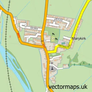
This Johnshaven street map is a detailed vector street map covering a 750m x 750m area. Select a larger area to create and download your own vector street map of Johnshaven.

Johnshaven is a village in Kincardineshire, in the North East Scotland of Scotland. The settlement falls within the West Aberdeenshire And Kincardine parliamentary constituency. It is served by the DD10 postcode district, with DD10 0 as the local postcode

The 750-metre map sample for Johnshaven covers 88 mapped buildings and approximately 14.6 km of road detail, of which 24 named roads are named. The immediate area includes 1 pub. The wider area around Johnshaven features 3 tourism points of interest, 1 food and drink venue and 3 hotels. To create a larger or custom map of Johnshaven, the map builder lets you define your own coverage area and download editable SVG, PDF and PNG files.

88Buildings
14.64 kmRoads
24Named roads
0Residents within 2 miles
Create your own

Create a larger editable map of Johnshaven

Choose any area you need and generate a high-quality vector map instantly. Perfect for print, planning, design, business and personal use.

Choose any location
Editable SVG files
Any size up to A0
PDF, PNG & more
Instant download
High quality guaranteed
Create My Custom Map
Secure, private & no credit card required
Johnshaven Vector Street Map
750m Sample
Johnshaven vector street map sample showing roads, buildings and local features in a 750 metre preview area
Buy Johnshaven Map Print from £12.95 Buy Johnshaven Digital Map from £6

This Johnshaven street map in Kincardineshire is available as downloadable SVG, PDF and PNG map files, or as a printed map for planning, business, display, education, local information and design work. You can also create a larger custom map area using the map selector.

What this Johnshaven map sample shows

Johnshaven lies within Aberdeenshire parish, part of Mearns ward in the Aberdeenshire local authority area. The postcode geography for this area includes the DD postcode area, the DD10 postcode district and the DD10 0 postcode sector. Residents fall under the Grampian for NHS services.

Local features near Johnshaven

Within 2 miles

Amenities and services in and around Johnshaven.

1 Campsites within 2 miles
3 Tourism & leisure
1 Food & drink
1 Pubs
3 Hotels

Counts are approximate and based on publicly available data.

Administrative and postcode information for Johnshaven

Johnshaven lies within Aberdeenshire parish, part of Mearns ward in the Aberdeenshire local authority area. The postcode geography for this area includes the DD postcode area, the DD10 postcode district and the DD10 0 postcode sector. Residents fall under the Grampian for NHS services.

Parish ABERDEENSHIRE
Ward Mearns
District / local authority Aberdeenshire
County Kincardineshire
Historic county Kincardineshire
Postcode district DD10
Postcode sector DD10 0
Parliamentary constituency West Aberdeenshire and Kincardine
Region North East Scotland
Country Scotland

Nearby street map samples around Johnshaven

Street map sample of Inverbervie, Kincardineshire Inverbervie Town - Kincardineshire - 4.0 miles Street map sample of Aberdeen, City of Aberdeen Aberdeen City - City of Aberdeen - 26.1 miles Street map sample of Gourdon, Kincardineshire Gourdon Village - Kincardineshire - 3.0 miles Street map sample of St Cyrus, Kincardineshire St Cyrus Village - Kincardineshire - 3.4 miles Street map sample of Arbuthnott, Kincardineshire Arbuthnott Village - Kincardineshire - 5.1 miles Street map sample of Fordoun, Kincardineshire Fordoun Village - Kincardineshire - 6.2 miles Street map sample of Hillside, Angus Hillside Village - Angus - 6.5 miles Street map sample of Roadside of Kinneff, Kincardineshire Roadside of Kinneff Village - Kincardineshire - 6.7 miles Street map sample of Craigo, Angus Craigo Village - Angus - 6.8 miles Street map sample of Marykirk, Kincardineshire Marykirk Village - Kincardineshire - 6.9 miles

More street maps in Kincardineshire

Street map sample of Gourdon, Kincardineshire Gourdon Village - 3.0 miles Street map sample of St Cyrus, Kincardineshire St Cyrus Village - 3.4 miles Street map sample of Inverbervie, Kincardineshire Inverbervie Town - 4.0 miles Street map sample of Arbuthnott, Kincardineshire Arbuthnott Village - 5.1 miles Street map sample of Laurencekirk, Kincardineshire Laurencekirk Town - 5.6 miles

750 metre map area coverage

Boundary, postcode and point of interest information for the 750m x 750m rectangle centred on this sample map.

Boundaries containing map centre

Constituency: West Aberdeenshire and Kincardine Co Const

District: Aberdeenshire

Icb: Grampian

Postcode District: DD10

Postcode Sector: DD10 0

Ward: Mearns Ward

Nearby boundaries intersecting sample

No additional intersecting boundaries found.

Postcode coverage

DD10 DD10 0

POI category counts

Hotel: 3

Holiday Rental Home: 2

Shopping: 2

Arts And Crafts: 1

Bed And Breakfast: 1

Carpet Cleaning: 1

Cottage: 1

Courier And Delivery Services: 1

Eat And Drink: 1

Ethical Grocery: 1

Sample points of interest

  • Starfish Studio Arts And Crafts
  • Seaforth Guest House Bed And Breakfast
  • Johnshaven Carpet Cleaning Services Carpet Cleaning
  • Myrtle Cottage Cottage
  • Evri ParcelShop Courier And Delivery Services
  • Zingy Tingy Beetroot Eat And Drink
  • Usan Salmon Fisheries Ltd. Ethical Grocery
  • Murray McBay & Co Food Beverage Service Distribution
  • The Anchor Hotel Gastropub
  • Odyssee hair design Hair Salon
  • Blackrock House - holiday rental Holiday Rental Home
  • Keyland Cottage Holiday Rental Home

Create a larger editable map of Johnshaven

This sample shows only a 750 metre area. To create a larger map of Johnshaven, use our map builder to choose your own coverage area, add titles and download editable SVG, PDF and PNG files.

Create a custom map of Johnshaven

Phone 01751 473136 | Copyright Vectormaps.uk 2026

Samples Customizer Privacy Disclaimer
Johnshaven Vector Street Map
Johnshaven enlarged street map sample showing a 750 metre preview area