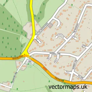
This Litlington street map is a detailed vector street map covering a 750m x 750m area. Select a larger area to create and download your own vector street map of Litlington.
The 750-metre map sample for Litlington covers 77 mapped buildings and approximately 5.9 km of road detail, of which 3 named roads are named. The immediate area includes 1 pub and 1 MOT station within 2 miles. The wider area around Litlington features 2 food and drink venues. To create a larger or custom map of Litlington, the map builder lets you define your own coverage area and download editable SVG, PDF and PNG files.
Create a larger editable map of Litlington
Choose any area you need and generate a high-quality vector map instantly. Perfect for print, planning, design, business and personal use.

This Litlington street map in East Sussex is available as downloadable SVG, PDF and PNG map files, or as a printed map for planning, business, display, education, local information and design work. You can also create a larger custom map area using the map selector.
What this Litlington map sample shows
Litlington lies within Cuckmere Valley Cp parish, part of South Downs ward in the Wealden District local authority area. The postcode geography for this area includes the BN postcode area, the BN26 postcode district and the BN26 5 postcode sector. Residents fall under the Nhs Sussex Integrated Care Board for NHS services.
Local features near Litlington
Within 2 milesAmenities and services in and around Litlington.
Administrative and postcode information for Litlington
The local authority covering Litlington is Wealden District, within the county of East Sussex. The settlement lies within South Downs ward and Cuckmere Valley Cp civil parish. The BN26 postcode district and BN26 5 postcode sector serve the immediate area. NHS provision in the area is delivered through East Sussex Healthcare Nhs Trust.
Nearby street map samples around Litlington

More street maps in East Sussex
750 metre map area coverage
Boundary, postcode and point of interest information for the 750m x 750m rectangle centred on this sample map.
Boundaries containing map centre
Constituency: Lewes Co Const
County: East Sussex County
District: Wealden District
Icb: NHS Surrey and Sussex ICB
Parish: Cuckmere Valley CP
Police Force: sussex
Postcode District: BN26
Postcode Sector: BN26 5
Ward: South Downs Ward
Nearby boundaries intersecting sample
Parish: Alfriston CP
Postcode coverage
POI category counts
Bar: 2
Brewery: 2
Tree Services: 2
Agriculture: 1
Anglican Church: 1
Business Advertising: 1
Church Cathedral: 1
Clothing Store: 1
Coffee Shop: 1
Flowers And Gifts Shop: 1
Sample points of interest
- Clapham Farm
- St Michael the Archangel
- Litlington Tea Gardens
- Plough and Harrow
- Long Man Brewery
- Long Man Brewery
- Litlington Gifts
- Church of St Michael the Archangel
- Litlington Crystal Store
- Liquid Spirit Coffee Roasters
- Litlington Crystal Store
- Ethical Seo
Create a larger editable map of Litlington
This sample shows only a 750 metre area. To create a larger map of Litlington, use our map builder to choose your own coverage area, add titles and download editable SVG, PDF and PNG files.
Create a custom map of Litlington