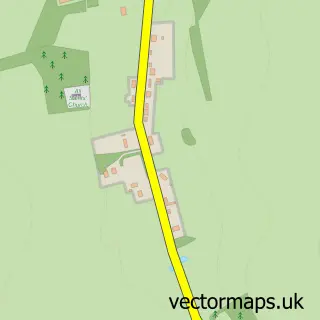
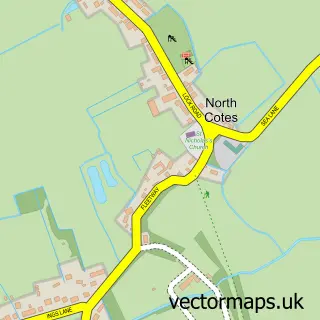
This Ludborough street map is a detailed vector street map covering a 750m x 750m area. Select a larger area to create and download your own vector street map of Ludborough.
The 750-metre map sample for Ludborough covers 121 mapped buildings and approximately 14.0 km of road detail, of which 6 named roads are named. The immediate area includes 1 GP surgery within 2 miles and 2 pubs. The wider area around Ludborough features 1 tourism point of interest and 2 food and drink venues. To create a larger or custom map of Ludborough, the map builder lets you define your own coverage area and download editable SVG, PDF and PNG files.
Create a larger editable map of Ludborough
Choose any area you need and generate a high-quality vector map instantly. Perfect for print, planning, design, business and personal use.

This Ludborough street map in Lincolnshire is available as downloadable SVG, PDF and PNG map files, or as a printed map for planning, business, display, education, local information and design work. You can also create a larger custom map area using the map selector.
What this Ludborough map sample shows
Ludborough lies within Ludborough Cp parish, part of Fulstow ward in the East Lindsey District local authority area. The postcode geography for this area includes the DN postcode area, the DN36 postcode district and the DN36 5 postcode sector. Residents fall under the Nhs Lincolnshire Integrated Care Board for NHS services.
Local features near Ludborough
Within 2 milesAmenities and services in and around Ludborough.
Administrative and postcode information for Ludborough
Ludborough lies within Ludborough Cp parish, part of Fulstow ward in the East Lindsey District local authority area. The postcode geography for this area includes the DN postcode area, the DN36 postcode district and the DN36 5 postcode sector. Residents fall under the Nhs Lincolnshire Integrated Care Board for NHS services.
Nearby street map samples around Ludborough

More street maps in Lincolnshire
750 metre map area coverage
Boundary, postcode and point of interest information for the 750m x 750m rectangle centred on this sample map.
Boundaries containing map centre
Constituency: Louth and Horncastle Co Const
County: Lincolnshire County
District: East Lindsey District
Icb: NHS Lincolnshire ICB
Parish: Ludborough CP
Police Force: lincolnshire
Postcode District: DN36
Postcode Sector: DN36 5
Ward: Fulstow Ward
Nearby boundaries intersecting sample
No additional intersecting boundaries found.
Postcode coverage
POI category counts
Pub: 2
Anglican Church: 1
Beverage Store: 1
Electrician: 1
Employment Agencies: 1
Food: 1
Landmark And Historical Building: 1
Marketing Consultant: 1
Sample points of interest
- St Marys, Ludborough
- Louth Potato Co
- Dynamic Electrical Services
- Mopp N Bucket Cleaning Services
- Louth Potato Co
- Railway Holiday
- Michael Carr Consultancy Ltd.
- Livesey Arms
- The Livesey Arms
Create a larger editable map of Ludborough
This sample shows only a 750 metre area. To create a larger map of Ludborough, use our map builder to choose your own coverage area, add titles and download editable SVG, PDF and PNG files.
Create a custom map of Ludborough