Vector Maps logo
Home Why it works Popular maps Districts Samples Customizer Create Your Map
VectorMaps.uk
Home Popular maps Districts Samples Customizer Create Your Map Privacy Disclaimer
Home / UK Maps / Kincardineshire / Marywell Map

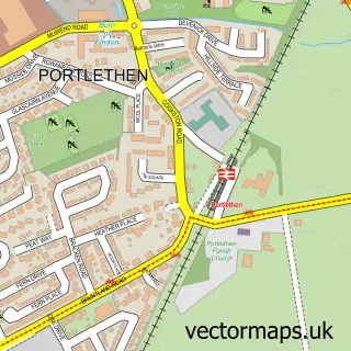
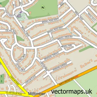
This Marywell street map is a detailed vector street map covering a 750m x 750m area. Select a larger area to create and download your own vector street map of Marywell.

Marywell is a village in Kincardineshire, in the North East Scotland of Scotland. The settlement falls within the West Aberdeenshire And Kincardine parliamentary constituency. It is served by the AB12 postcode district, with AB12 4 as the local postcode s

The 750-metre map sample for Marywell covers 51 mapped buildings and approximately 17.0 km of road detail, of which 7 named roads are named. The immediate area includes 1 GP surgery within 2 miles and 6 MOT stations within 2 miles. The wider area around Marywell features 1 hotel. To create a larger or custom map of Marywell, the map builder lets you define your own coverage area and download editable SVG, PDF and PNG files.

51Buildings
17.04 kmRoads
7Named roads
0Residents within 2 miles
Create your own

Create a larger editable map of Marywell

Choose any area you need and generate a high-quality vector map instantly. Perfect for print, planning, design, business and personal use.

Choose any location
Editable SVG files
Any size up to A0
PDF, PNG & more
Instant download
High quality guaranteed
Create My Custom Map
Secure, private & no credit card required
Marywell Vector Street Map
750m Sample
Marywell vector street map sample showing roads, buildings and local features in a 750 metre preview area
Buy Marywell Map Print from £12.95 Buy Marywell Digital Map from £6

This Marywell street map in Kincardineshire is available as downloadable SVG, PDF and PNG map files, or as a printed map for planning, business, display, education, local information and design work. You can also create a larger custom map area using the map selector.

What this Marywell map sample shows

Marywell lies within Aberdeenshire parish, part of North Kincardine ward in the Aberdeenshire local authority area. The postcode geography for this area includes the AB postcode area, the AB12 postcode district and the AB12 4 postcode sector. Residents fall under the Grampian for NHS services.

Local features near Marywell

Within 2 miles

Amenities and services in and around Marywell.

1 GP surgeries within 2 miles
6 MOT stations within 2 miles
1 Hotels

Counts are approximate and based on publicly available data.

Administrative and postcode information for Marywell

Marywell lies within Aberdeenshire parish, part of North Kincardine ward in the Aberdeenshire local authority area. The postcode geography for this area includes the AB postcode area, the AB12 postcode district and the AB12 4 postcode sector. Residents fall under the Grampian for NHS services.

Parish ABERDEENSHIRE
Ward North Kincardine
District / local authority Aberdeenshire
County Kincardineshire
Historic county Kincardineshire
Postcode district AB12
Postcode sector AB12 4
Parliamentary constituency West Aberdeenshire and Kincardine
Region North East Scotland
Country Scotland

Nearby street map samples around Marywell

Street map sample of Portlethen, Kincardineshire Portlethen Town - Kincardineshire - 1.6 miles Street map sample of Aberdeen, City of Aberdeen Aberdeen City - City of Aberdeen - 4.5 miles Street map sample of Findon, Kincardineshire Findon Village - Kincardineshire - 1.1 miles Street map sample of Portlethen Village, Kincardineshire Portlethen Village Village - Kincardineshire - 1.9 miles Street map sample of Downies, Kincardineshire Downies Village - Kincardineshire - 2.6 miles Street map sample of Cammachmore, Kincardineshire Cammachmore Village - Kincardineshire - 3.1 miles Street map sample of Chapelton of Elsick, Kincardineshire Chapelton of Elsick Village - Kincardineshire - 4.2 miles Street map sample of Kirkton of Maryculter, Kincardineshire Kirkton of Maryculter Village - Kincardineshire - 4.6 miles Street map sample of Muchalls, Kincardineshire Muchalls Village - Kincardineshire - 4.7 miles Street map sample of Milltimber, City of Aberdeen Milltimber Village - City of Aberdeen - 4.7 miles

More street maps in Kincardineshire

Street map sample of Findon, Kincardineshire Findon Village - 1.1 miles Street map sample of Portlethen, Kincardineshire Portlethen Town - 1.6 miles Street map sample of Portlethen Village, Kincardineshire Portlethen Village Village - 1.9 miles Street map sample of Downies, Kincardineshire Downies Village - 2.6 miles Street map sample of Cammachmore, Kincardineshire Cammachmore Village - 3.1 miles

750 metre map area coverage

Boundary, postcode and point of interest information for the 750m x 750m rectangle centred on this sample map.

Boundaries containing map centre

Constituency: West Aberdeenshire and Kincardine Co Const

District: Aberdeenshire

Icb: Grampian

Postcode District: AB12

Postcode Sector: AB12 4

Ward: North Kincardine Ward

Nearby boundaries intersecting sample

Postcode Sector: AB12 3

Postcode coverage

AB12 AB12 4 AB12 3

POI category counts

Garbage Collection Service: 4

Advertising Agency: 1

Business Management Services: 1

Contractor: 1

Fire Protection Service: 1

Home Developer: 1

Hotel: 1

Pet Store: 1

Real Estate: 1

Retail: 1

Sample points of interest

  • North East Reprographics Limited Advertising Agency
  • HSS Training Business Management Services
  • Apex Tubulars Contractor
  • Flare Fire Safety Engineering Fire Protection Service
  • E I S Waste Services Garbage Collection Service
  • EIS Waste Services Garbage Collection Service
  • One Stop Waste Solutions Garbage Collection Service
  • One Stop Waste Solutions Garbage Collection Service
  • marywell cp Home Developer
  • Apartrooms Hotel
  • AJM Pet Supplies Pet Store
  • Marywell Park Real Estate

Create a larger editable map of Marywell

This sample shows only a 750 metre area. To create a larger map of Marywell, use our map builder to choose your own coverage area, add titles and download editable SVG, PDF and PNG files.

Create a custom map of Marywell

Phone 01751 473136 | Copyright Vectormaps.uk 2026

Samples Customizer Privacy Disclaimer
Marywell Vector Street Map
Marywell enlarged street map sample showing a 750 metre preview area