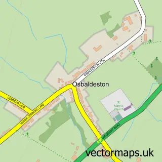
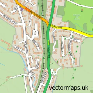
This Mellor street map is a detailed vector street map covering a 750m x 750m area. Select a larger area to create and download your own vector street map of Mellor.
The 750-metre map sample for Mellor covers 328 mapped buildings and approximately 13.8 km of road detail, of which 22 named roads are named. The immediate area includes 1 school, 2 GP surgeries within 2 miles, 2 pubs and 4 MOT stations within 2 miles. The wider area around Mellor features 2 food and drink venues. To create a larger or custom map of Mellor, the map builder lets you define your own coverage area and download editable SVG, PDF and PNG files.
Create a larger editable map of Mellor
Choose any area you need and generate a high-quality vector map instantly. Perfect for print, planning, design, business and personal use.

This Mellor street map in Lancashire is available as downloadable SVG, PDF and PNG map files, or as a printed map for planning, business, display, education, local information and design work. You can also create a larger custom map area using the map selector.
What this Mellor map sample shows
Mellor lies within Mellor Cp parish, part of Mellor ward in the Ribble Valley District (B) local authority area. The postcode geography for this area includes the BB postcode area, the BB2 postcode district and the BB2 7 postcode sector. Residents fall under the Nhs Lancashire And South Cumbria Integrated Care Board for NHS services.
Local features near Mellor
Within 2 milesAmenities and services in and around Mellor.
Administrative and postcode information for Mellor
Mellor lies within Mellor Cp parish, part of Mellor ward in the Ribble Valley District (B) local authority area. The postcode geography for this area includes the BB postcode area, the BB2 postcode district and the BB2 7 postcode sector. Residents fall under the Nhs Lancashire And South Cumbria Integrated Care Board for NHS services.
Nearby street map samples around Mellor


More street maps in Lancashire
750 metre map area coverage
Boundary, postcode and point of interest information for the 750m x 750m rectangle centred on this sample map.
Boundaries containing map centre
Constituency: Ribble Valley Co Const
County: Lancashire County
District: Ribble Valley District (B)
Icb: NHS Lancashire and South Cumbria ICB
Parish: Mellor CP
Police Force: lancashire
Postcode District: BB2
Postcode Sector: BB2 7
Ward: Mellor Ward
Nearby boundaries intersecting sample
No additional intersecting boundaries found.
Postcode coverage
POI category counts
Convenience Store: 2
Elementary School: 2
Pub: 2
Advertising Agency: 1
Anglican Church: 1
Atms: 1
Building Supply Store: 1
Business Consulting: 1
Butcher Shop: 1
Catholic Church: 1
Sample points of interest
- Salt Marketing
- St Mary's Mellor
- One Stop (Cash Score) (Protected), Mellor
- Barrymore Maintenance
- Enavate Solutions
- Frank Littler & Sons Ltd
- Mellor Parish Church
- Sweet Pea. Children's preloved clothes.
- Mellor Methodist Church
- Mellor Village Hall
- One Stop
- Spar
Create a larger editable map of Mellor
This sample shows only a 750 metre area. To create a larger map of Mellor, use our map builder to choose your own coverage area, add titles and download editable SVG, PDF and PNG files.
Create a custom map of Mellor