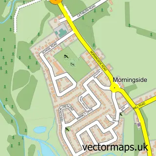
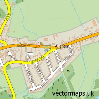
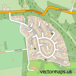
This Newmains street map is a detailed vector street map covering a 750m x 750m area. Select a larger area to create and download your own vector street map of Newmains.
The 750-metre map sample for Newmains covers 256 mapped buildings and approximately 10.7 km of road detail, of which 23 named roads are named. The immediate area includes 1 GP surgery, with 5 within 2 miles and 1 MOT station, with 6 within 2 miles. The wider area around Newmains features 1 tourism point of interest, 2 food and drink venues and 1 hotel. To create a larger or custom map of Newmains, the map builder lets you define your own coverage area and download editable SVG, PDF and PNG files.
Create a larger editable map of Newmains
Choose any area you need and generate a high-quality vector map instantly. Perfect for print, planning, design, business and personal use.

This Newmains street map in Lanarkshire is available as downloadable SVG, PDF and PNG map files, or as a printed map for planning, business, display, education, local information and design work. You can also create a larger custom map area using the map selector.
What this Newmains map sample shows
Newmains lies within North Lanarkshire parish, part of Murdostoun ward in the North Lanarkshire local authority area. The postcode geography for this area includes the ML postcode area, the ML2 postcode district and the ML2 9 postcode sector. Residents fall under the Lanarkshire for NHS services.
Local features near Newmains
Within 2 milesAmenities and services in and around Newmains.
Administrative and postcode information for Newmains
The local authority covering Newmains is North Lanarkshire, within the county of Lanarkshire. The settlement lies within Murdostoun ward and North Lanarkshire civil parish. The ML2 postcode district and ML2 9 postcode sector serve the immediate area. NHS provision in the area is delivered through Lanarkshire.
Nearby street map samples around Newmains

More street maps in Lanarkshire
750 metre map area coverage
Boundary, postcode and point of interest information for the 750m x 750m rectangle centred on this sample map.
Boundaries containing map centre
Constituency: Airdrie and Shotts Co Const
District: North Lanarkshire
Icb: Lanarkshire
Postcode District: ML2
Postcode Sector: ML2 9
Ward: Murdostoun Ward
Nearby boundaries intersecting sample
Postcode Sector: ML2 8
Ward: Fortissat Ward
Postcode coverage
POI category counts
Barber: 4
Beauty Salon: 4
Contractor: 4
Gas Station: 4
Automotive Repair: 3
Hair Salon: 3
Indian Restaurant: 3
Passport And Visa Services: 3
Pharmacy: 3
Supermarket: 3
Sample points of interest
- Crosshill Stables
- XS Taekwon-do Newmains
- Certas Energy - Newmains
- Newmains Car Wash & Valet Centre
- Blaney Commercials
- DB Auto Repair Centre
- Noisebusters
- VAG Auto Technicians
- InstaVolt Charging Station
- Newmains MOT & Service Centre
- AP Barbers Newmains
- D barbers shop
Create a larger editable map of Newmains
This sample shows only a 750 metre area. To create a larger map of Newmains, use our map builder to choose your own coverage area, add titles and download editable SVG, PDF and PNG files.
Create a custom map of Newmains