Vector Maps logo
Home Why it works Popular maps Districts Samples Customizer Create Your Map
VectorMaps.uk
Home Popular maps Districts Samples Customizer Create Your Map Privacy Disclaimer
Home / UK Maps / Roxburgh, Ettrick and Lauderdale / Newtown St Boswells Map

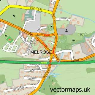
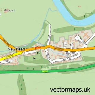
This Newtown St Boswells street map is a detailed vector street map covering a 750m x 750m area. Select a larger area to create and download your own vector street map of Newtown St Boswells.

Newtown St Boswells is a village in Roxburgh, Ettrick And Lauderdale, in the South Scotland of Scotland. Historically, the area formed part of Roxburghshire. The settlement falls within the Berwickshire, Roxburgh And Selkirk parliamentary constituency. It

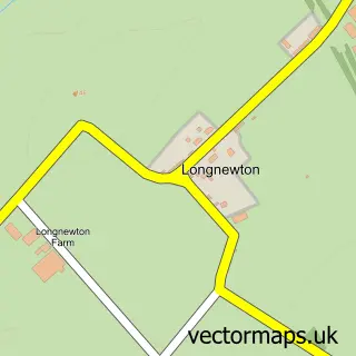
The 750-metre map sample for Newtown St Boswells covers 243 mapped buildings and approximately 13.8 km of road detail, of which 12 named roads are named. The immediate area includes 1 GP surgery, 1 pub and 3 MOT stations, with 5 within 2 miles. The wider area around Newtown St Boswells features 1 tourism point of interest and 1 food and drink venue. To create a larger or custom map of Newtown St Boswells, the map builder lets you define your own coverage area and download editable SVG, PDF and PNG files.

243Buildings
13.84 kmRoads
12Named roads
0Residents within 2 miles
Create your own

Create a larger editable map of Newtown St Boswells

Choose any area you need and generate a high-quality vector map instantly. Perfect for print, planning, design, business and personal use.

Choose any location
Editable SVG files
Any size up to A0
PDF, PNG & more
Instant download
High quality guaranteed
Create My Custom Map
Secure, private & no credit card required
Newtown St Boswells Vector Street Map
750m Sample
Newtown St Boswells vector street map sample showing roads, buildings and local features in a 750 metre preview area
Buy Newtown St Boswells Map Print from £12.95 Buy Newtown St Boswells Digital Map from £6

This Newtown St Boswells street map in Roxburgh, Ettrick and Lauderdale is available as downloadable SVG, PDF and PNG map files, or as a printed map for planning, business, display, education, local information and design work. You can also create a larger custom map area using the map selector.

What this Newtown St Boswells map sample shows

Newtown St Boswells lies within Scottish Borders parish, part of Selkirkshire ward in the Scottish Borders local authority area. The postcode geography for this area includes the TD postcode area, the TD6 postcode district and the TD6 0 postcode sector. Residents fall under the Borders for NHS services.

Local features near Newtown St Boswells

Within 2 miles

Amenities and services in and around Newtown St Boswells.

1 GP surgeries 1 within 2 miles
3 MOT stations 5 within 2 miles
1 Tourism & leisure
1 Food & drink
1 Pubs
3 Healthcare POIs
1 Vehicle services

Counts are approximate and based on publicly available data.

Administrative and postcode information for Newtown St Boswells

Newtown St Boswells lies within Scottish Borders parish, part of Selkirkshire ward in the Scottish Borders local authority area. The postcode geography for this area includes the TD postcode area, the TD6 postcode district and the TD6 0 postcode sector. Residents fall under the Borders for NHS services.

Parish SCOTTISH BORDERS
Ward Selkirkshire
District / local authority Scottish Borders
County Roxburgh, Ettrick and Lauderdale
Historic county Roxburghshire
Postcode district TD6
Postcode sector TD6 0
Parliamentary constituency Berwickshire, Roxburgh and Selkirk
Region South Scotland
Country Scotland

Nearby street map samples around Newtown St Boswells

Street map sample of Melrose, Roxburgh, Ettrick and Lauderdale Melrose Town - Roxburgh, Ettrick and Lauderdale - 2.3 miles Street map sample of Edinburgh, City of Edinburgh Edinburgh City - City of Edinburgh - 32.8 miles Street map sample of Dryburgh, Roxburgh, Ettrick and Lauderdale Dryburgh Village - Roxburgh, Ettrick and Lauderdale - 0.9 miles Street map sample of St Boswells, Roxburgh, Ettrick and Lauderdale St Boswells Village - Roxburgh, Ettrick and Lauderdale - 1.2 miles Street map sample of Bowden, Roxburgh, Ettrick and Lauderdale Bowden Village - Roxburgh, Ettrick and Lauderdale - 1.6 miles Street map sample of Newstead, Roxburgh, Ettrick and Lauderdale Newstead Village - Roxburgh, Ettrick and Lauderdale - 1.8 miles Street map sample of Clintmains, Roxburgh, Ettrick and Lauderdale Clintmains Village - Roxburgh, Ettrick and Lauderdale - 2.3 miles Street map sample of Maxton, Roxburgh, Ettrick and Lauderdale Maxton Village - Roxburgh, Ettrick and Lauderdale - 2.4 miles Street map sample of Redpath, Roxburgh, Ettrick and Lauderdale Redpath Village - Roxburgh, Ettrick and Lauderdale - 2.5 miles Street map sample of Longnewton, Roxburgh, Ettrick and Lauderdale Longnewton Village - Roxburgh, Ettrick and Lauderdale - 2.6 miles

More street maps in Roxburgh, Ettrick and Lauderdale

Street map sample of Dryburgh, Roxburgh, Ettrick and Lauderdale Dryburgh Village - 0.9 miles Street map sample of St Boswells, Roxburgh, Ettrick and Lauderdale St Boswells Village - 1.2 miles Street map sample of Bowden, Roxburgh, Ettrick and Lauderdale Bowden Village - 1.6 miles Street map sample of Newstead, Roxburgh, Ettrick and Lauderdale Newstead Village - 1.8 miles Street map sample of Clintmains, Roxburgh, Ettrick and Lauderdale Clintmains Village - 2.3 miles

750 metre map area coverage

Boundary, postcode and point of interest information for the 750m x 750m rectangle centred on this sample map.

Boundaries containing map centre

Constituency: Berwickshire, Roxburgh and Selkirk Co Const

District: Scottish Borders

Icb: Borders

Postcode District: TD6

Postcode Sector: TD6 0

Ward: Selkirkshire Ward

Nearby boundaries intersecting sample

Postcode Sector: TD6 9

Postcode coverage

TD6 TD6 0 TD6 9

POI category counts

Framing Store: 4

Building Supply Store: 2

College University: 2

Doctor: 2

Life Insurance: 2

Podiatrist: 2

Post Office: 2

Agricultural Service: 1

Art Restoration Service: 1

Auction House: 1

Sample points of interest

  • StBoswells&WoolerMarts Agricultural Service
  • Andrew Raphael Antique Restoration Art Restoration Service
  • St Boswells's Auction Mart Auction House
  • Kool kampers Auto Detailing
  • Serviceline Automotive Repair
  • RBS Bank Credit Union
  • Travis Perkins Building Supply Store
  • Travis Perkins Building Supply Store
  • Border Engineering Training Association Business Management Services
  • Club Japan Imports Car Dealer
  • Cooks Van Hire Car Rental Agency
  • Newtown Church Catholic Church

Create a larger editable map of Newtown St Boswells

This sample shows only a 750 metre area. To create a larger map of Newtown St Boswells, use our map builder to choose your own coverage area, add titles and download editable SVG, PDF and PNG files.

Create a custom map of Newtown St Boswells

Phone 01751 473136 | Copyright Vectormaps.uk 2026

Samples Customizer Privacy Disclaimer
Newtown St Boswells Vector Street Map
Newtown St Boswells enlarged street map sample showing a 750 metre preview area