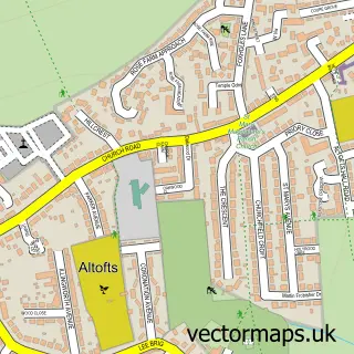
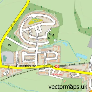
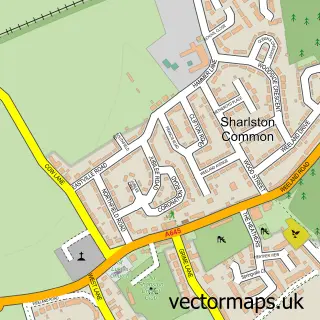
This Normanton street map is a detailed vector street map covering a 750m x 750m area. Select a larger area to create and download your own vector street map of Normanton.
The 750-metre map sample for Normanton covers 395 mapped buildings and approximately 19.8 km of road detail, of which 43 named roads are named. The immediate area includes 2 schools, 1 railway station, 1 GP surgery, with 3 within 2 miles and 10 pubs among other local services. The wider area around Normanton features 3 tourism points of interest and 23 food and drink venues. To create a larger or custom map of Normanton, the map builder lets you define your own coverage area and download editable SVG, PDF and PNG files.
Create a larger editable map of Normanton
Choose any area you need and generate a high-quality vector map instantly. Perfect for print, planning, design, business and personal use.

This Normanton street map in West Yorkshire is available as downloadable SVG, PDF and PNG map files, or as a printed map for planning, business, display, education, local information and design work. You can also create a larger custom map area using the map selector.
What this Normanton map sample shows
Normanton lies within Normanton Cp parish, part of Normanton ward in the Wakefield District (B) local authority area. The postcode geography for this area includes the WF postcode area, the WF6 postcode district and the WF6 2 postcode sector. Residents fall under the Nhs West Yorkshire Integrated Care Board for NHS services.
Local features near Normanton
Within 2 milesAmenities and services in and around Normanton.
Administrative and postcode information for Normanton
The local authority covering Normanton is Wakefield District (B), within the county of West Yorkshire. The settlement lies within Normanton ward and Normanton Cp civil parish. The WF6 postcode district and WF6 2 postcode sector serve the immediate area. NHS provision in the area is delivered through Mid Yorkshire Teaching Nhs Trust.
Nearby street map samples around Normanton

More street maps in West Yorkshire
750 metre map area coverage
Boundary, postcode and point of interest information for the 750m x 750m rectangle centred on this sample map.
Boundaries containing map centre
Constituency: Normanton and Hemsworth Co Const
District: Wakefield District (B)
Icb: NHS West Yorkshire ICB
Parish: Normanton and Altofts CP
Police Force: west yorkshire
Postcode District: WF6
Postcode Sector: WF6 2
Ward: Normanton Ward
Nearby boundaries intersecting sample
Constituency: Pontefract, Castleford and Knottingley Co Const
Postcode Sector: WF6 1
Ward: Altofts and Whitwood Ward
Postcode coverage
POI category counts
Beauty Salon: 11
Pub: 10
Flowers And Gifts Shop: 8
Barber: 7
Automotive Repair: 6
Banks: 6
Dance School: 6
Dentist: 6
Martial Arts Club: 6
Cafe: 5
Sample points of interest
- Hammond & Co
- Normanton Sports Acro
- The Cleansing Rooms
- Evan Moran & Sons Funfairs
- Shaws Amusements
- All Saints Parish Church Normanton
- All Saints' Parish Church
- DM Appliance Services
- Meter Manager
- DMS Architecture
- Breslin Building Surveys
- DMS Architecture
Create a larger editable map of Normanton
This sample shows only a 750 metre area. To create a larger map of Normanton, use our map builder to choose your own coverage area, add titles and download editable SVG, PDF and PNG files.
Create a custom map of Normanton