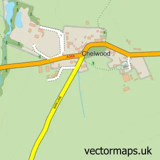
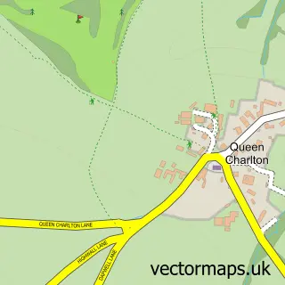
This Pensford street map is a detailed vector street map covering a 750m x 750m area. Select a larger area to create and download your own vector street map of Pensford.
The 750-metre map sample for Pensford covers 180 mapped buildings and approximately 14.8 km of road detail, of which 14 named roads are named. The immediate area includes 1 school, 2 pubs and 1 MOT station, with 3 within 2 miles. The wider area around Pensford features 1 tourism point of interest and 2 food and drink venues. To create a larger or custom map of Pensford, the map builder lets you define your own coverage area and download editable SVG, PDF and PNG files.
Create a larger editable map of Pensford
Choose any area you need and generate a high-quality vector map instantly. Perfect for print, planning, design, business and personal use.

This Pensford street map in Somerset is available as downloadable SVG, PDF and PNG map files, or as a printed map for planning, business, display, education, local information and design work. You can also create a larger custom map area using the map selector.
What this Pensford map sample shows
Pensford lies within Publow Cp parish, part of Publow & Whitchurch ward in the Bath And North East Somerset local authority area. The postcode geography for this area includes the BS postcode area, the BS39 postcode district and the BS39 4 postcode sector. Residents fall under the Nhs Bath And North East Somerset, Swindon And Wiltshire Integrated Care Board for NHS services.
Local features near Pensford
Within 2 milesAmenities and services in and around Pensford.
Administrative and postcode information for Pensford
The local authority covering Pensford is Bath And North East Somerset, within the county of Somerset. The settlement lies within Publow & Whitchurch ward and Publow Cp civil parish. The BS39 postcode district and BS39 4 postcode sector serve the immediate area. NHS provision in the area is delivered through Royal United Hospitals Bath Nhs Foundation Trust.
Nearby street map samples around Pensford

More street maps in Somerset
750 metre map area coverage
Boundary, postcode and point of interest information for the 750m x 750m rectangle centred on this sample map.
Boundaries containing map centre
Constituency: North East Somerset and Hanham Co Const
District: Bath and North East Somerset
Icb: NHS Bath and North East Somerset Swindon and Wiltshire ICB
Parish: Publow CP
Police Force: avon and somerset
Postcode District: BS39
Postcode Sector: BS39 4
Ward: Publow & Whitchurch Ward
Nearby boundaries intersecting sample
Parish: Stanton Drew CP
Ward: Chew Valley Ward
Postcode coverage
POI category counts
Pub: 2
Anglican Church: 1
Arts And Entertainment: 1
Beauty Salon: 1
Car Dealer: 1
Cleaning Services: 1
Community Center: 1
Day Care Preschool: 1
Electrician: 1
Elementary School: 1
Sample points of interest
- St Thomas a Becket's Church
- Melanie East Photography
- IBrowEnvy
- South Bristol Motor Company
- Dustin Time
- Pensford Memorial Hall
- The Woodland Kindergarten
- Chew Valley Electrics
- Pensford Primary School
- Terra Bella Gardens
- Rising Sun
- Pensford Post Office
Create a larger editable map of Pensford
This sample shows only a 750 metre area. To create a larger map of Pensford, use our map builder to choose your own coverage area, add titles and download editable SVG, PDF and PNG files.
Create a custom map of Pensford