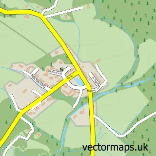
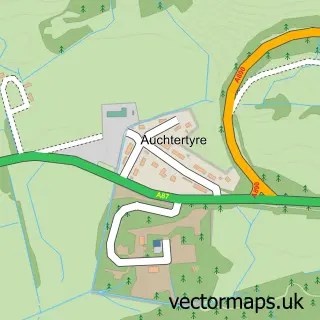
This Plockton street map is a detailed vector street map covering a 750m x 750m area. Select a larger area to create and download your own vector street map of Plockton.
The 750-metre map sample for Plockton covers 30 mapped buildings and approximately 5.8 km of road detail, of which 4 named roads are named. The immediate area includes 1 pub. The wider area around Plockton features 2 tourism points of interest, 3 food and drink venues and 4 hotels. To create a larger or custom map of Plockton, the map builder lets you define your own coverage area and download editable SVG, PDF and PNG files.
Create a larger editable map of Plockton
Choose any area you need and generate a high-quality vector map instantly. Perfect for print, planning, design, business and personal use.

This Plockton street map in Ross and Cromarty is available as downloadable SVG, PDF and PNG map files, or as a printed map for planning, business, display, education, local information and design work. You can also create a larger custom map area using the map selector.
What this Plockton map sample shows
Plockton lies within Highland parish, part of Wester Ross, Strathpeffer And Lochalsh ward in the Highland local authority area. The postcode geography for this area includes the IV postcode area, the IV52 postcode district and the IV52 8 postcode sector. Residents fall under the Highland for NHS services.
Local features near Plockton
Within 2 milesAmenities and services in and around Plockton.
Administrative and postcode information for Plockton
Plockton lies within Highland parish, part of Wester Ross, Strathpeffer And Lochalsh ward in the Highland local authority area. The postcode geography for this area includes the IV postcode area, the IV52 postcode district and the IV52 8 postcode sector. Residents fall under the Highland for NHS services.
Nearby street map samples around Plockton


More street maps in Ross and Cromarty
750 metre map area coverage
Boundary, postcode and point of interest information for the 750m x 750m rectangle centred on this sample map.
Boundaries containing map centre
Constituency: Inverness, Skye and West Ross-shire Co Const
District: Highland
Icb: Highland
Postcode District: IV52
Postcode Sector: IV52 8
Ward: Wester Ross, Strathpeffer and Lochalsh Ward
Nearby boundaries intersecting sample
No additional intersecting boundaries found.
Postcode coverage
POI category counts
Hotel: 4
Seafood Restaurant: 4
Bed And Breakfast: 3
Art Gallery: 2
Landmark And Historical Building: 2
Advertising Agency: 1
Arts And Entertainment: 1
Boat Tours: 1
Canoe And Kayak Hire Service: 1
Coffee Shop: 1
Sample points of interest
- Meghan’s
- Plockton Inn
- The Studio Plockton
- Peter Mackenna
- JDF Macdonald
- Mackenzie's Bed and Breakfast
- The Haven Guest House
- Calum's Seal Trips
- Sea Kayak Plockton
- Plockton Distillery
- Plockton Village Hall
- Plockton Primary School
Create a larger editable map of Plockton
This sample shows only a 750 metre area. To create a larger map of Plockton, use our map builder to choose your own coverage area, add titles and download editable SVG, PDF and PNG files.
Create a custom map of Plockton