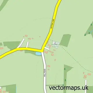
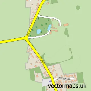
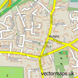
This Postwick street map is a detailed vector street map covering a 750m x 750m area. Select a larger area to create and download your own vector street map of Postwick.
The 750-metre map sample for Postwick covers 113 mapped buildings and approximately 7.4 km of road detail, of which 9 named roads are named. The immediate area includes 1 GP surgery within 2 miles and 2 MOT stations within 2 miles. The wider area around Postwick features 1 hotel and 1 campsite within 2 miles. To create a larger or custom map of Postwick, the map builder lets you define your own coverage area and download editable SVG, PDF and PNG files.
Create a larger editable map of Postwick
Choose any area you need and generate a high-quality vector map instantly. Perfect for print, planning, design, business and personal use.

This Postwick street map in Norfolk is available as downloadable SVG, PDF and PNG map files, or as a printed map for planning, business, display, education, local information and design work. You can also create a larger custom map area using the map selector.
What this Postwick map sample shows
Postwick lies within Postwick With Witton Cp parish, part of Brundall ward in the Broadland District local authority area. The postcode geography for this area includes the NR postcode area, the NR13 postcode district and the NR13 5 postcode sector. Residents fall under the Nhs Norfolk And Waveney Integrated Care Board for NHS services.
Local features near Postwick
Within 2 milesAmenities and services in and around Postwick.
Administrative and postcode information for Postwick
Postwick lies within Postwick With Witton Cp parish, part of Brundall ward in the Broadland District local authority area. The postcode geography for this area includes the NR postcode area, the NR13 postcode district and the NR13 5 postcode sector. Residents fall under the Nhs Norfolk And Waveney Integrated Care Board for NHS services.
Nearby street map samples around Postwick

More street maps in Norfolk
750 metre map area coverage
Boundary, postcode and point of interest information for the 750m x 750m rectangle centred on this sample map.
Boundaries containing map centre
Constituency: Broadland and Fakenham Co Const
County: Norfolk County
District: Broadland District
Icb: NHS Norfolk and Waveney ICB
Parish: Postwick with Witton CP
Police Force: norfolk
Postcode District: NR13
Postcode Sector: NR13 5
Ward: Brundall Ward
Nearby boundaries intersecting sample
No additional intersecting boundaries found.
Postcode coverage
POI category counts
Anglican Church: 1
Auto Upholstery: 1
Automotive Repair: 1
Building Supply Store: 1
Doctor: 1
Driving School: 1
Hair Removal: 1
Hotel: 1
Pest Control Service: 1
Printing Services: 1
Sample points of interest
- Postwick: All Saints
- Claire Fiddy Soft Furnishing
- Redline Auto Recovery
- T Jarvis & Son
- Jane Hancy Electrolysis Specialist BIAE Norwich
- Flying Colours
- Electrolysis specialist Jane Hancy BIAE Norwich
- Broadlands Lodge Care Home
- Pest Off
- Postwick Village Hall
- Postwick Village Hall & Social Club
- Norwich Cricket Club
Create a larger editable map of Postwick
This sample shows only a 750 metre area. To create a larger map of Postwick, use our map builder to choose your own coverage area, add titles and download editable SVG, PDF and PNG files.
Create a custom map of Postwick