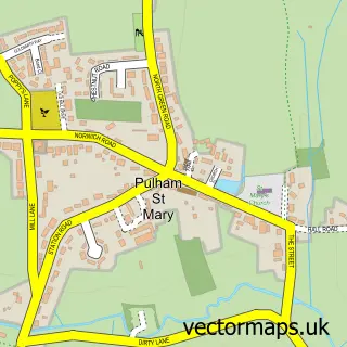
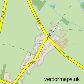
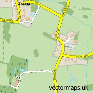
This Pulham Market street map is a detailed vector street map covering a 750m x 750m area. Select a larger area to create and download your own vector street map of Pulham Market.
The 750-metre map sample for Pulham Market covers 225 mapped buildings and approximately 12.6 km of road detail, of which 15 named roads are named. The immediate area includes 1 school, 1 GP surgery, 2 pubs and 2 MOT stations within 2 miles. The wider area around Pulham Market features 2 food and drink venues and 1 hotel. To create a larger or custom map of Pulham Market, the map builder lets you define your own coverage area and download editable SVG, PDF and PNG files.
Create a larger editable map of Pulham Market
Choose any area you need and generate a high-quality vector map instantly. Perfect for print, planning, design, business and personal use.

This Pulham Market street map in Norfolk is available as downloadable SVG, PDF and PNG map files, or as a printed map for planning, business, display, education, local information and design work. You can also create a larger custom map area using the map selector.
What this Pulham Market map sample shows
Pulham Market lies within Pulham Market Cp parish, part of Beck Vale, Dickleburgh & Scole ward in the South Norfolk District local authority area. The postcode geography for this area includes the IP postcode area, the IP21 postcode district and the IP21 4 postcode sector. Residents fall under the Nhs Norfolk And Waveney Integrated Care Board for NHS services.
Local features near Pulham Market
Within 2 milesAmenities and services in and around Pulham Market.
Administrative and postcode information for Pulham Market
Pulham Market lies within Pulham Market Cp parish, part of Beck Vale, Dickleburgh & Scole ward in the South Norfolk District local authority area. The postcode geography for this area includes the IP postcode area, the IP21 postcode district and the IP21 4 postcode sector. Residents fall under the Nhs Norfolk And Waveney Integrated Care Board for NHS services.
Nearby street map samples around Pulham Market

More street maps in Norfolk
750 metre map area coverage
Boundary, postcode and point of interest information for the 750m x 750m rectangle centred on this sample map.
Boundaries containing map centre
Constituency: Waveney Valley Co Const
County: Norfolk County
District: South Norfolk District
Icb: NHS Norfolk and Waveney ICB
Parish: Pulham Market CP
Police Force: norfolk
Postcode District: IP21
Postcode Sector: IP21 4
Ward: Beck Vale, Dickleburgh & Scole Ward
Nearby boundaries intersecting sample
No additional intersecting boundaries found.
Postcode coverage
POI category counts
Advertising Agency: 2
Pub: 2
Shipping Center: 2
Anglican Church: 1
Arts And Crafts: 1
Arts And Entertainment: 1
Beauty And Spa: 1
Bed And Breakfast: 1
Building Contractor: 1
Community Services Non Profits: 1
Sample points of interest
- Copy Concept
- Scream Blue Murder
- St Mary Magdalene's, Pulham Market
- JDM Woodcraft
- Pulham Market Village Hall
- Olivia's Hair Studio
- The Old Bakery
- Timber Windows Norfolk
- Pulham Market Memorial Hall
- Sam's Local Shopper
- Cakes 2 Crumbs
- Pulham C of E Primary School
Create a larger editable map of Pulham Market
This sample shows only a 750 metre area. To create a larger map of Pulham Market, use our map builder to choose your own coverage area, add titles and download editable SVG, PDF and PNG files.
Create a custom map of Pulham Market