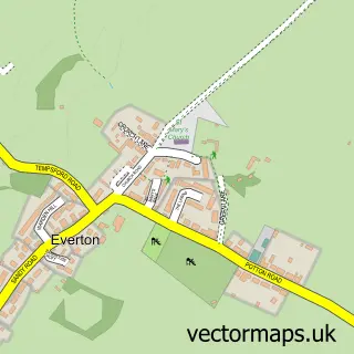
This Roxton street map is a detailed vector street map covering a 750m x 750m area. Select a larger area to create and download your own vector street map of Roxton.
The 750-metre map sample for Roxton covers 213 mapped buildings and approximately 10.1 km of road detail, of which 8 named roads are named. The immediate area includes 1 school and 1 pub. The wider area around Roxton features 1 tourism point of interest and 2 food and drink venues. To create a larger or custom map of Roxton, the map builder lets you define your own coverage area and download editable SVG, PDF and PNG files.
Create a larger editable map of Roxton
Choose any area you need and generate a high-quality vector map instantly. Perfect for print, planning, design, business and personal use.

This Roxton street map in Bedfordshire is available as downloadable SVG, PDF and PNG map files, or as a printed map for planning, business, display, education, local information and design work. You can also create a larger custom map area using the map selector.
What this Roxton map sample shows
Roxton lies within Roxton Cp parish, part of Wyboston ward in the Bedford (B) local authority area. The postcode geography for this area includes the MK postcode area, the MK44 postcode district and the MK44 3 postcode sector. Residents fall under the Nhs Bedfordshire, Luton And Milton Keynes Integrated Care Board for NHS services.
Local features near Roxton
Within 2 milesAmenities and services in and around Roxton.
Administrative and postcode information for Roxton
The local authority covering Roxton is Bedford (B), within the county of Bedfordshire. The settlement lies within Wyboston ward and Roxton Cp civil parish. The MK44 postcode district and MK44 3 postcode sector serve the immediate area. NHS provision in the area is delivered through Bedfordshire Hospitals Nhs Foundation Trust.
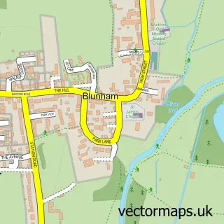
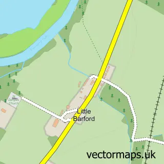
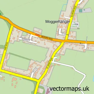
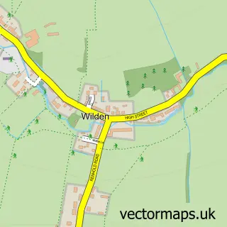
Nearby street map samples around Roxton

More street maps in Bedfordshire
750 metre map area coverage
Boundary, postcode and point of interest information for the 750m x 750m rectangle centred on this sample map.
Boundaries containing map centre
Constituency: North Bedfordshire Co Const
District: Bedford (B)
Icb: NHS Central East ICB
Parish: Roxton CP
Police Force: bedfordshire
Postcode District: MK44
Postcode Sector: MK44 3
Ward: Wyboston Ward
Nearby boundaries intersecting sample
Parish: Wyboston, Chawston and Colesden CP
Postcode coverage
POI category counts
Elementary School: 2
Professional Services: 2
Shipping Center: 2
Anglican Church: 1
Arts And Entertainment: 1
Bed And Breakfast: 1
Bridal Shop: 1
Building Supply Store: 1
Cafe: 1
Community Center: 1
Sample points of interest
- St Mary Magdalene
- Roxton
- Church Farm
- Townhouse Bridal - Off The Peg Bridal Boutique
- Buildway Construction
- Little Acorn Cafe
- Roxton Village Hall
- Huntree Fencing
- Post Office Travel Money
- Roxton V a Lower School
- Roxton V a Lower School
- Roxton, Bedfordshire
Create a larger editable map of Roxton
This sample shows only a 750 metre area. To create a larger map of Roxton, use our map builder to choose your own coverage area, add titles and download editable SVG, PDF and PNG files.
Create a custom map of Roxton