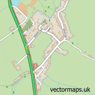
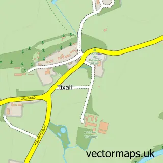
This Salt street map is a detailed vector street map covering a 750m x 750m area. Select a larger area to create and download your own vector street map of Salt.
The 750-metre map sample for Salt covers 90 mapped buildings and approximately 9.9 km of road detail, of which 5 named roads are named. The immediate area includes 1 pub and 1 MOT station within 2 miles. The wider area around Salt features 1 tourism point of interest, 1 food and drink venue and 1 hotel. To create a larger or custom map of Salt, the map builder lets you define your own coverage area and download editable SVG, PDF and PNG files.
Create a larger editable map of Salt
Choose any area you need and generate a high-quality vector map instantly. Perfect for print, planning, design, business and personal use.

This Salt street map in Staffordshire is available as downloadable SVG, PDF and PNG map files, or as a printed map for planning, business, display, education, local information and design work. You can also create a larger custom map area using the map selector.
What this Salt map sample shows
Salt lies within Salt And Enson Cp parish, part of Milwich ward in the Stafford District (B) local authority area. The postcode geography for this area includes the ST postcode area, the ST18 postcode district and the ST18 0 postcode sector. Residents fall under the Nhs Staffordshire And Stoke-On-Trent Integrated Care Board for NHS services.
Local features near Salt
Within 2 milesAmenities and services in and around Salt.
Administrative and postcode information for Salt
Salt lies within Salt And Enson Cp parish, part of Milwich ward in the Stafford District (B) local authority area. The postcode geography for this area includes the ST postcode area, the ST18 postcode district and the ST18 0 postcode sector. Residents fall under the Nhs Staffordshire And Stoke-On-Trent Integrated Care Board for NHS services.
Nearby street map samples around Salt

More street maps in Staffordshire
750 metre map area coverage
Boundary, postcode and point of interest information for the 750m x 750m rectangle centred on this sample map.
Boundaries containing map centre
Constituency: Stone, Great Wyrley and Penkridge Co Const
County: Staffordshire County
District: Stafford District (B)
Icb: NHS Staffordshire and Stoke-on-Trent ICB
Parish: Salt and Enson CP
Police Force: staffordshire
Postcode District: ST18
Postcode Sector: ST18 0
Ward: Milwich Ward
Nearby boundaries intersecting sample
Parish: Sandon and Burston CP
Postcode coverage
POI category counts
Anglican Church: 1
Automotive: 1
Church Cathedral: 1
Community Center: 1
Gardener: 1
Hotel: 1
Landmark And Historical Building: 1
Pub: 1
Religious Organization: 1
Train Station: 1
Sample points of interest
- St James the Great, Salt, part of the Mid-Trent Churches Team
- TRT Mobile Mechanic And Diagnostic Stafford
- St James's Church
- Salt Village Hall
- Trent Grounds Maintenance
- The Hollybush Inn
- Salt, Staffordshire
- The Holly Bush at Salt
- Salt and Hopton Churches
- Salt and Sandon railway station
Create a larger editable map of Salt
This sample shows only a 750 metre area. To create a larger map of Salt, use our map builder to choose your own coverage area, add titles and download editable SVG, PDF and PNG files.
Create a custom map of Salt