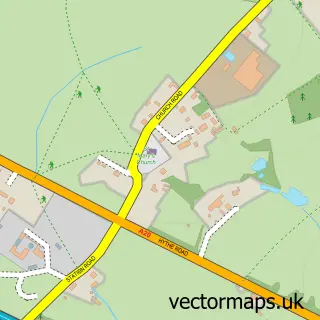
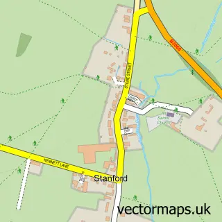
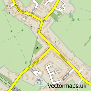
This Sellindge street map is a detailed vector street map covering a 750m x 750m area. Select a larger area to create and download your own vector street map of Sellindge.
The 750-metre map sample for Sellindge covers 134 mapped buildings and approximately 11.0 km of road detail, of which 6 named roads are named. The immediate area includes 1 GP surgery within 2 miles and 1 MOT station, with 2 within 2 miles. To create a larger or custom map of Sellindge, the map builder lets you define your own coverage area and download editable SVG, PDF and PNG files.
Create a larger editable map of Sellindge
Choose any area you need and generate a high-quality vector map instantly. Perfect for print, planning, design, business and personal use.

This Sellindge street map in Kent is available as downloadable SVG, PDF and PNG map files, or as a printed map for planning, business, display, education, local information and design work. You can also create a larger custom map area using the map selector.
What this Sellindge map sample shows
Sellindge lies within Sellindge Cp parish, part of North Downs West ward in the Folkestone And Hythe District local authority area. The postcode geography for this area includes the TN postcode area, the TN25 postcode district and the TN25 6 postcode sector. Residents fall under the Nhs Kent And Medway Integrated Care Board for NHS services.
Local features near Sellindge
Within 2 milesAmenities and services in and around Sellindge.
Administrative and postcode information for Sellindge
The local authority covering Sellindge is Folkestone And Hythe District, within the county of Kent. The settlement lies within North Downs West ward and Sellindge Cp civil parish. The TN25 postcode district and TN25 6 postcode sector serve the immediate area. NHS provision in the area is delivered through East Kent Hospitals University Nhs Foundation Trust.
Nearby street map samples around Sellindge

More street maps in Kent
750 metre map area coverage
Boundary, postcode and point of interest information for the 750m x 750m rectangle centred on this sample map.
Boundaries containing map centre
Constituency: Ashford Co Const
County: Kent County
District: Folkestone and Hythe District
Icb: NHS Kent and Medway ICB
Parish: Sellindge CP
Police Force: kent
Postcode District: TN25
Postcode Sector: TN25 6
Ward: North Downs West Ward
Nearby boundaries intersecting sample
District: Ashford District (B)
Parish: Smeeth CP
Ward: Bircholt Ward
Postcode coverage
POI category counts
Building Supply Store: 2
Advertising Agency: 1
Anglican Church: 1
Automotive Repair: 1
Car Broker: 1
Car Dealer: 1
Gym: 1
Pet Groomer: 1
Real Estate Service: 1
Sample points of interest
- Wilsher Marketing Services
- St Mary the Virgin, Sellindge
- Bob Fishers Garage
- Cosy Fires
- GPS Plumbing & Heating
- DP Leasing Ltd.
- Unipart Car Care Centre
- the Gym House
- Dress to Impress
- Board Sign Hub
Create a larger editable map of Sellindge
This sample shows only a 750 metre area. To create a larger map of Sellindge, use our map builder to choose your own coverage area, add titles and download editable SVG, PDF and PNG files.
Create a custom map of Sellindge