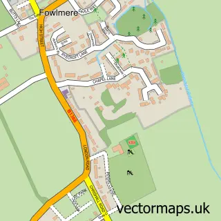
This Shepreth street map is a detailed vector street map covering a 750m x 750m area. Select a larger area to create and download your own vector street map of Shepreth.
The 750-metre map sample for Shepreth covers 230 mapped buildings and approximately 9.7 km of road detail, of which 14 named roads are named. The immediate area includes 1 railway station, 1 pub and 3 MOT stations within 2 miles. The wider area around Shepreth features 1 food and drink venue and 1 campsite within 2 miles. To create a larger or custom map of Shepreth, the map builder lets you define your own coverage area and download editable SVG, PDF and PNG files.
Create a larger editable map of Shepreth
Choose any area you need and generate a high-quality vector map instantly. Perfect for print, planning, design, business and personal use.

This Shepreth street map in Cambridgeshire is available as downloadable SVG, PDF and PNG map files, or as a printed map for planning, business, display, education, local information and design work. You can also create a larger custom map area using the map selector.
What this Shepreth map sample shows
Shepreth lies within Shepreth Cp parish, part of Melbourn ward in the South Cambridgeshire District local authority area. The postcode geography for this area includes the SG postcode area, the SG8 postcode district and the SG8 6 postcode sector. Residents fall under the Nhs Cambridgeshire And Peterborough Integrated Care Board for NHS services.
Local features near Shepreth
Within 2 milesAmenities and services in and around Shepreth.
Administrative and postcode information for Shepreth
The local authority covering Shepreth is South Cambridgeshire District, within the county of Cambridgeshire. The settlement lies within Melbourn ward and Shepreth Cp civil parish. The SG8 postcode district and SG8 6 postcode sector serve the immediate area. NHS provision in the area is delivered through Cambridge University Hospitals Nhs Foundation Trust.
Nearby street map samples around Shepreth


More street maps in Cambridgeshire
750 metre map area coverage
Boundary, postcode and point of interest information for the 750m x 750m rectangle centred on this sample map.
Boundaries containing map centre
Constituency: South Cambridgeshire Co Const
County: Cambridgeshire County
District: South Cambridgeshire District
Icb: NHS Central East ICB
Parish: Shepreth CP
Police Force: cambridgeshire
Postcode District: SG8
Postcode Sector: SG8 6
Ward: Melbourn Ward
Nearby boundaries intersecting sample
No additional intersecting boundaries found.
Postcode coverage
POI category counts
Environmental Conservation Organization: 2
Industrial Equipment: 2
Professional Services: 2
Train Station: 2
Advertising Agency: 1
Appliance Manufacturer: 1
Botanical Garden: 1
Building Supply Store: 1
Business Management Services: 1
Business Manufacturing And Supply: 1
Sample points of interest
- Simmons Pugh
- Munby & Lewis
- Docwra's Manor Garden
- Roofing Ventilation
- Origin 8 Ltd.
- Bexwell Farm Logs
- SWCC - Shepreth Hedgehog Hospital
- Anukampa Bhikkhuni Project
- Happy Bunnies Nursery School
- Baker Associates Hydro Solutions LLP
- B. A. Hydro Solutions
- B a Hydro Solutions
Create a larger editable map of Shepreth
This sample shows only a 750 metre area. To create a larger map of Shepreth, use our map builder to choose your own coverage area, add titles and download editable SVG, PDF and PNG files.
Create a custom map of Shepreth