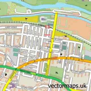
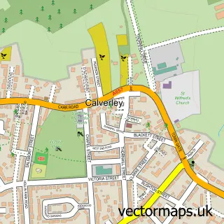
This Shipley street map is a detailed vector street map covering a 750m x 750m area. Select a larger area to create and download your own vector street map of Shipley.
The 750-metre map sample for Shipley covers 233 mapped buildings and approximately 23.8 km of road detail, of which 54 named roads are named. The immediate area includes 1 school, 1 railway station, 1 GP surgery, with 11 within 2 miles and 10 pubs among other local services. The wider area around Shipley features 5 tourism points of interest, 24 food and drink venues and 3 hotels. To create a larger or custom map of Shipley, the map builder lets you define your own coverage area and download editable SVG, PDF and PNG files.
Create a larger editable map of Shipley
Choose any area you need and generate a high-quality vector map instantly. Perfect for print, planning, design, business and personal use.

This Shipley street map in West Yorkshire is available as downloadable SVG, PDF and PNG map files, or as a printed map for planning, business, display, education, local information and design work. You can also create a larger custom map area using the map selector.
What this Shipley map sample shows
Shipley lies within Bradford District (B) parish, part of Windhill And Wrose ward in the Bradford District (B) local authority area. The postcode geography for this area includes the BD postcode area, the BD18 postcode district and the BD18 2 postcode sector. Residents fall under the Nhs West Yorkshire Integrated Care Board for NHS services.
Local features near Shipley
Within 2 milesAmenities and services in and around Shipley.
Administrative and postcode information for Shipley
The local authority covering Shipley is Bradford District (B), within the county of West Yorkshire. The settlement lies within Windhill And Wrose ward and Bradford District (B) civil parish. The BD18 postcode district and BD18 2 postcode sector serve the immediate area. NHS provision in the area is delivered through Bradford Teaching Hospitals Nhs Foundation Trust.
Nearby street map samples around Shipley

More street maps in West Yorkshire
750 metre map area coverage
Boundary, postcode and point of interest information for the 750m x 750m rectangle centred on this sample map.
Boundaries containing map centre
Constituency: Shipley Co Const
District: Bradford District (B)
Icb: NHS West Yorkshire ICB
Parish: Shipley CP
Police Force: west yorkshire
Postcode District: BD18
Postcode Sector: BD18 3
Ward: Shipley Ward
Nearby boundaries intersecting sample
Constituency: Bradford West Boro Const
Postcode District: BD17
Postcode Sector: BD17 7, BD18 2
Ward: Heaton Ward, Windhill and Wrose Ward
Postcode coverage
POI category counts
Hair Salon: 12
Automotive Repair: 11
Pub: 10
Beauty Salon: 9
Professional Services: 9
Real Estate Agent: 9
Community Services Non Profits: 8
Retail: 8
Clothing Store: 7
Employment Agencies: 7
Sample points of interest
- Hazzad Embroidery & Promotional Gifts
- Allen Chinese Medical Centre
- Home & Media
- YAPP - Yorkshire Appliances
- Young Masters
- Katie Bentley Ceramics
- Scraptastic
- Shipley Haberdashery
- Tuliptoppers
- Distant Future Animation Studio
- Kirkgate Studios & Workshop
- Cash machine 33-34 Market Square
Create a larger editable map of Shipley
This sample shows only a 750 metre area. To create a larger map of Shipley, use our map builder to choose your own coverage area, add titles and download editable SVG, PDF and PNG files.
Create a custom map of Shipley