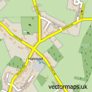
This Shoreham street map is a detailed vector street map covering a 750m x 750m area. Select a larger area to create and download your own vector street map of Shoreham.
The 750-metre map sample for Shoreham covers 154 mapped buildings and approximately 5.9 km of road detail, of which 12 named roads are named. The immediate area includes 1 school, 1 GP surgery within 2 miles, 2 pubs and 2 MOT stations within 2 miles. The wider area around Shoreham features 2 tourism points of interest and 4 food and drink venues. To create a larger or custom map of Shoreham, the map builder lets you define your own coverage area and download editable SVG, PDF and PNG files.
Create a larger editable map of Shoreham
Choose any area you need and generate a high-quality vector map instantly. Perfect for print, planning, design, business and personal use.

This Shoreham street map in Kent is available as downloadable SVG, PDF and PNG map files, or as a printed map for planning, business, display, education, local information and design work. You can also create a larger custom map area using the map selector.
What this Shoreham map sample shows
Shoreham lies within Shoreham Cp parish, part of Otford And Shoreham ward in the Sevenoaks District local authority area. The postcode geography for this area includes the TN postcode area, the TN14 postcode district and the TN14 7 postcode sector. Residents fall under the Nhs Kent And Medway Integrated Care Board for NHS services.
Local features near Shoreham
Within 2 milesAmenities and services in and around Shoreham.
Administrative and postcode information for Shoreham
Shoreham lies within Shoreham Cp parish, part of Otford And Shoreham ward in the Sevenoaks District local authority area. The postcode geography for this area includes the TN postcode area, the TN14 postcode district and the TN14 7 postcode sector. Residents fall under the Nhs Kent And Medway Integrated Care Board for NHS services.
Nearby street map samples around Shoreham


More street maps in Kent
750 metre map area coverage
Boundary, postcode and point of interest information for the 750m x 750m rectangle centred on this sample map.
Boundaries containing map centre
Constituency: Sevenoaks Co Const
County: Kent County
District: Sevenoaks District
Icb: NHS Kent and Medway ICB
Parish: Shoreham CP
Police Force: kent
Postcode District: TN14
Postcode Sector: TN14 7
Ward: Otford and Shoreham Ward
Nearby boundaries intersecting sample
No additional intersecting boundaries found.
Postcode coverage
POI category counts
Cafe: 2
Professional Services: 2
Pub: 2
Anglican Church: 1
Beverage Store: 1
Books Mags Music And Video: 1
Business: 1
Church Cathedral: 1
Community Center: 1
Cricket Ground: 1
Sample points of interest
- St Peter and St Paul's Church Shoreham Kent
- Shoreham Village Stores
- Post Office-Shoreham
- Data 3 0
- Battle of Britain cafe
- The Honey Pot Cafe and Tea Rooms
- Shoreham Village Church
- Shoreham Village Hall
- Shoreham Cricket
- Savills Sevenoaks
- Shoreham & Otford Cricket Club
- Shoreham Church Stay and Play
Create a larger editable map of Shoreham
This sample shows only a 750 metre area. To create a larger map of Shoreham, use our map builder to choose your own coverage area, add titles and download editable SVG, PDF and PNG files.
Create a custom map of Shoreham