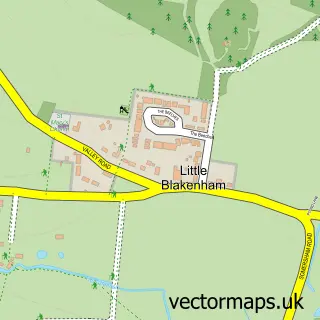
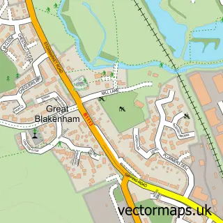
This Somersham street map is a detailed vector street map covering a 750m x 750m area. Select a larger area to create and download your own vector street map of Somersham.
The 750-metre map sample for Somersham covers 178 mapped buildings and approximately 9.8 km of road detail, of which 11 named roads are named. The immediate area includes 1 pub and 1 MOT station within 2 miles. The wider area around Somersham features 3 tourism points of interest and 1 food and drink venue. To create a larger or custom map of Somersham, the map builder lets you define your own coverage area and download editable SVG, PDF and PNG files.
Create a larger editable map of Somersham
Choose any area you need and generate a high-quality vector map instantly. Perfect for print, planning, design, business and personal use.

This Somersham street map in Suffolk is available as downloadable SVG, PDF and PNG map files, or as a printed map for planning, business, display, education, local information and design work. You can also create a larger custom map area using the map selector.
What this Somersham map sample shows
Somersham lies within Somersham Cp parish, part of Blakenham ward in the Mid Suffolk District local authority area. The postcode geography for this area includes the IP postcode area, the IP8 postcode district and the IP8 4 postcode sector. Residents fall under the Nhs Suffolk And North East Essex Integrated Care Board for NHS services.
Local features near Somersham
Within 2 milesAmenities and services in and around Somersham.
Administrative and postcode information for Somersham
The local authority covering Somersham is Mid Suffolk District, within the county of Suffolk. The settlement lies within Blakenham ward and Somersham Cp civil parish. The IP8 postcode district and IP8 4 postcode sector serve the immediate area. NHS provision in the area is delivered through East Suffolk And North Essex Nhs Foundation Trust.
Nearby street map samples around Somersham

More street maps in Suffolk
750 metre map area coverage
Boundary, postcode and point of interest information for the 750m x 750m rectangle centred on this sample map.
Boundaries containing map centre
Constituency: Central Suffolk and North Ipswich Co Const
County: Suffolk County
District: Mid Suffolk District
Icb: NHS Essex ICB
Parish: Somersham CP
Police Force: suffolk
Postcode District: IP8
Postcode Sector: IP8 4
Ward: Blakenham Ward
Nearby boundaries intersecting sample
Parish: Nettlestead CP
Postcode coverage
POI category counts
Park: 2
Accountant: 1
Baptist Church: 1
Bar: 1
Grocery Store: 1
Health Consultant: 1
Home Health Care: 1
Landmark And Historical Building: 1
Pub: 1
Water Treatment Equipment And Services: 1
Sample points of interest
- Mid Suffolk Accountancy Services
- Somersham Baptist Church Suffolk | Ipswich
- Spiros Garden Bar
- Somersham and District Community Shop
- Blue Square Safety Ltd.
- Sunflower Homecare
- Somersham, Suffolk
- Somersham Village Playing Field
- Somersham park
- Duke of Marlborough
- Pumps & Filtration Ltd.
Create a larger editable map of Somersham
This sample shows only a 750 metre area. To create a larger map of Somersham, use our map builder to choose your own coverage area, add titles and download editable SVG, PDF and PNG files.
Create a custom map of Somersham