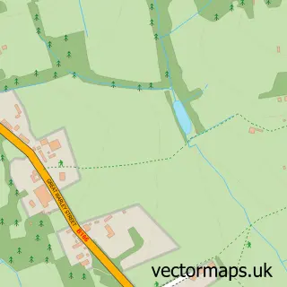
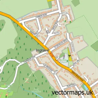
This South Weald street map is a detailed vector street map covering a 750m x 750m area. Select a larger area to create and download your own vector street map of South Weald.
The 750-metre map sample for South Weald covers 73 mapped buildings and approximately 7.7 km of road detail, of which 3 named roads are named. The immediate area includes 1 school, 5 GP surgeries within 2 miles and 10 MOT stations within 2 miles. The wider area around South Weald features 2 tourism points of interest and 2 food and drink venues. To create a larger or custom map of South Weald, the map builder lets you define your own coverage area and download editable SVG, PDF and PNG files.
Create a larger editable map of South Weald
Choose any area you need and generate a high-quality vector map instantly. Perfect for print, planning, design, business and personal use.

This South Weald street map in Essex is available as downloadable SVG, PDF and PNG map files, or as a printed map for planning, business, display, education, local information and design work. You can also create a larger custom map area using the map selector.
What this South Weald map sample shows
South Weald lies within Essex County parish, part of South Weald ward in the Brentwood District (B) local authority area. The postcode geography for this area includes the CM postcode area, the CM14 postcode district and the CM14 5 postcode sector. Residents fall under the Nhs Mid And South Essex Integrated Care Board for NHS services.
Local features near South Weald
Within 2 milesAmenities and services in and around South Weald.
Administrative and postcode information for South Weald
The local authority covering South Weald is Brentwood District (B), within the county of Essex. The settlement lies within South Weald ward and Essex County civil parish. The CM14 postcode district and CM14 5 postcode sector serve the immediate area. NHS provision in the area is delivered through Mid And South Essex Nhs Foundation Trust.
Nearby street map samples around South Weald

More street maps in Essex
750 metre map area coverage
Boundary, postcode and point of interest information for the 750m x 750m rectangle centred on this sample map.
Boundaries containing map centre
Constituency: Brentwood and Ongar Co Const
County: Essex County
District: Brentwood District (B)
Icb: NHS Essex ICB
Police Force: essex
Postcode District: CM14
Postcode Sector: CM14 5
Ward: Brizes, Stondon Massey & South Weald Ward
Nearby boundaries intersecting sample
No additional intersecting boundaries found.
Postcode coverage
POI category counts
Anglican Church: 3
Park: 2
Bridal Shop: 1
Cafe: 1
Elementary School: 1
Gym: 1
Pet Services: 1
Restaurant: 1
Sports Club And League: 1
Swimming Instructor: 1
Sample points of interest
- South Weald: St Peter
- St Peter's Church
- St. Peter C of E Church
- Wedding Dresses Essex by White Wedding House
- Wigley Bush Café
- St Peter's Church of England Primary School
- Rob Swaine - Online Coach
- Weald Park
- Weald Stick Man Play Trail
- Dog Training Centre of Excellence
- Saints at The Tower Arms
- Brookweald Cricket Club
Create a larger editable map of South Weald
This sample shows only a 750 metre area. To create a larger map of South Weald, use our map builder to choose your own coverage area, add titles and download editable SVG, PDF and PNG files.
Create a custom map of South Weald