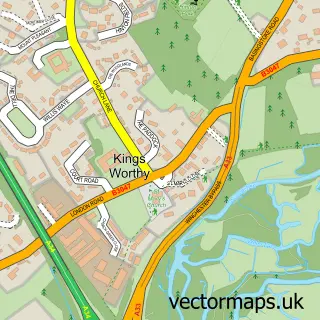
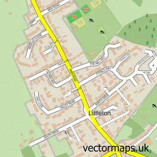
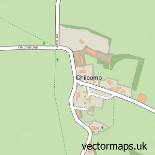
This Springvale street map is a detailed vector street map covering a 750m x 750m area. Select a larger area to create and download your own vector street map of Springvale.
The 750-metre map sample for Springvale covers 505 mapped buildings and approximately 13.0 km of road detail, of which 34 named roads are named. The immediate area includes 4 MOT stations within 2 miles. To create a larger or custom map of Springvale, the map builder lets you define your own coverage area and download editable SVG, PDF and PNG files.
Create a larger editable map of Springvale
Choose any area you need and generate a high-quality vector map instantly. Perfect for print, planning, design, business and personal use.

This Springvale street map in Hampshire is available as downloadable SVG, PDF and PNG map files, or as a printed map for planning, business, display, education, local information and design work. You can also create a larger custom map area using the map selector.
What this Springvale map sample shows
Springvale lies within Kings Worthy Cp parish, part of The Worthys ward in the Winchester District (B) local authority area. The postcode geography for this area includes the SO postcode area, the SO23 postcode district and the SO23 7 postcode sector. Residents fall under the Nhs Hampshire And Isle Of Wight Integrated Care Board for NHS services.
Local features near Springvale
Within 2 milesAmenities and services in and around Springvale.
Administrative and postcode information for Springvale
The local authority covering Springvale is Winchester District (B), within the county of Hampshire. The settlement lies within The Worthys ward and Kings Worthy Cp civil parish. The SO23 postcode district and SO23 7 postcode sector serve the immediate area. NHS provision in the area is delivered through Hampshire Hospitals Nhs Foundation Trust.
Nearby street map samples around Springvale

More street maps in Hampshire
750 metre map area coverage
Boundary, postcode and point of interest information for the 750m x 750m rectangle centred on this sample map.
Boundaries containing map centre
Constituency: Winchester Co Const
County: Hampshire County
District: Winchester District (B)
Icb: NHS Hampshire and Isle of Wight ICB
Parish: Kings Worthy CP
Police Force: hampshire
Postcode District: SO23
Postcode Sector: SO23 7
Ward: The Worthys Ward
Nearby boundaries intersecting sample
No additional intersecting boundaries found.
Postcode coverage
POI category counts
Convenience Store: 5
Driving School: 3
Gardener: 3
Pest Control Service: 3
Contractor: 2
Janitorial Services: 2
Pet Groomer: 2
Anglican Church: 1
Bakery: 1
Beauty Salon: 1
Sample points of interest
- St Mary's Chapel
- Mama Brown's Cakes
- Topaz kings Worthy
- Crowded House
- Worthy Word Processing
- Tubbs Hall & Kings Worthy Community Centre
- SC Asbestos Ltd
- The Myers Touch
- Kingsworthy Premier Stores
- Premier
- Premier Springvale Stores
- Springvale Stores
Create a larger editable map of Springvale
This sample shows only a 750 metre area. To create a larger map of Springvale, use our map builder to choose your own coverage area, add titles and download editable SVG, PDF and PNG files.
Create a custom map of Springvale