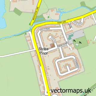
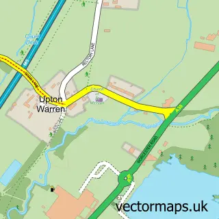
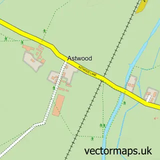
This Stoke Pound street map is a detailed vector street map covering a 750m x 750m area. Select a larger area to create and download your own vector street map of Stoke Pound.
The 750-metre map sample for Stoke Pound covers 74 mapped buildings and approximately 16.2 km of road detail, of which 3 named roads are named. The immediate area includes 1 school, 3 GP surgeries within 2 miles, 2 pubs and 13 MOT stations within 2 miles. The wider area around Stoke Pound features 2 food and drink venues. To create a larger or custom map of Stoke Pound, the map builder lets you define your own coverage area and download editable SVG, PDF and PNG files.
Create a larger editable map of Stoke Pound
Choose any area you need and generate a high-quality vector map instantly. Perfect for print, planning, design, business and personal use.

This Stoke Pound street map in Worcestershire is available as downloadable SVG, PDF and PNG map files, or as a printed map for planning, business, display, education, local information and design work. You can also create a larger custom map area using the map selector.
What this Stoke Pound map sample shows
Stoke Pound lies within Stoke Cp parish, part of Avoncroft ward in the Bromsgrove District local authority area. The postcode geography for this area includes the B postcode area, the B60 postcode district and the B60 4 postcode sector. Residents fall under the Nhs Herefordshire And Worcestershire Integrated Care Board for NHS services.
Local features near Stoke Pound
Within 2 milesAmenities and services in and around Stoke Pound.
Administrative and postcode information for Stoke Pound
Stoke Pound lies within Stoke Cp parish, part of Avoncroft ward in the Bromsgrove District local authority area. The postcode geography for this area includes the B postcode area, the B60 postcode district and the B60 4 postcode sector. Residents fall under the Nhs Herefordshire And Worcestershire Integrated Care Board for NHS services.
Nearby street map samples around Stoke Pound

More street maps in Worcestershire
750 metre map area coverage
Boundary, postcode and point of interest information for the 750m x 750m rectangle centred on this sample map.
Boundaries containing map centre
Constituency: Bromsgrove Co Const
County: Worcestershire County
District: Bromsgrove District
Icb: NHS Herefordshire and Worcestershire ICB
Parish: Stoke CP
Police Force: west mercia
Postcode District: B60
Postcode Sector: B60 3
Ward: Avoncroft Ward
Nearby boundaries intersecting sample
Postcode Sector: B60 4
Ward: Aston Fields Ward
Postcode coverage
POI category counts
Pub: 2
Business Consulting: 1
Cottage: 1
Gastropub: 1
Printing Equipment And Supply: 1
Professional Services: 1
Real Estate Agent: 1
Sample points of interest
- Aspire Business Partnership
- Lock Cottage
- Queens Head Inn
- Ribbon Writer
- Rae Prince Photography
- The Queen's Head
- The Queens Head
- Hinton Group
Create a larger editable map of Stoke Pound
This sample shows only a 750 metre area. To create a larger map of Stoke Pound, use our map builder to choose your own coverage area, add titles and download editable SVG, PDF and PNG files.
Create a custom map of Stoke Pound