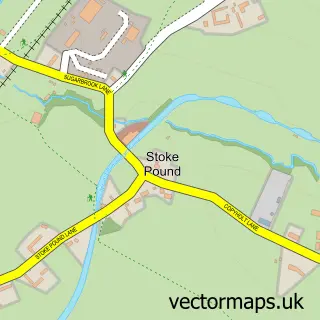
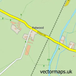
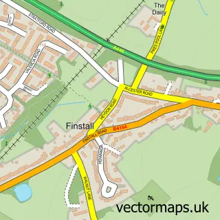
This Stoke Prior street map is a detailed vector street map covering a 750m x 750m area. Select a larger area to create and download your own vector street map of Stoke Prior.
The 750-metre map sample for Stoke Prior covers 193 mapped buildings and approximately 26.8 km of road detail, of which 8 named roads are named. The immediate area includes 1 school and 9 MOT stations within 2 miles. To create a larger or custom map of Stoke Prior, the map builder lets you define your own coverage area and download editable SVG, PDF and PNG files.
Create a larger editable map of Stoke Prior
Choose any area you need and generate a high-quality vector map instantly. Perfect for print, planning, design, business and personal use.

This Stoke Prior street map in Worcestershire is available as downloadable SVG, PDF and PNG map files, or as a printed map for planning, business, display, education, local information and design work. You can also create a larger custom map area using the map selector.
What this Stoke Prior map sample shows
Stoke Prior lies within Stoke Cp parish, part of Avoncroft ward in the Bromsgrove District local authority area. The postcode geography for this area includes the B postcode area, the B60 postcode district and the B60 4 postcode sector. Residents fall under the Nhs Herefordshire And Worcestershire Integrated Care Board for NHS services.
Local features near Stoke Prior
Within 2 milesAmenities and services in and around Stoke Prior.
Administrative and postcode information for Stoke Prior
The local authority covering Stoke Prior is Bromsgrove District, within the county of Worcestershire. The settlement lies within Avoncroft ward and Stoke Cp civil parish. The B60 postcode district and B60 4 postcode sector serve the immediate area. NHS provision in the area is delivered through Worcestershire Acute Hospitals Nhs Trust.
Nearby street map samples around Stoke Prior

More street maps in Worcestershire
750 metre map area coverage
Boundary, postcode and point of interest information for the 750m x 750m rectangle centred on this sample map.
Boundaries containing map centre
Constituency: Bromsgrove Co Const
County: Worcestershire County
District: Bromsgrove District
Icb: NHS Herefordshire and Worcestershire ICB
Parish: Stoke CP
Police Force: west mercia
Postcode District: B60
Postcode Sector: B60 4
Ward: Avoncroft Ward
Nearby boundaries intersecting sample
Constituency: Redditch Co Const
District: Wychavon District
Parish: Dodderhill CP, Upton Warren CP
Postcode District: B61
Postcode Sector: B61 7
Ward: Dodderhill Ward
Postcode coverage
POI category counts
Professional Services: 3
Automotive Repair: 2
Beauty Salon: 2
Gardener: 2
Photography Store And Services: 2
Shipping Center: 2
Arts And Crafts: 1
Bakery: 1
Butcher Shop: 1
Construction Services: 1
Sample points of interest
- JAS Corporate Embroidery
- Ayler auto repair
- Option 1 Sportscars
- Abigail's Cake Co.
- Capelli Hair Studio
- Derma Collective
- The Butcheress
- OakTree Fencing Limited
- Costcutter
- Stoke Prior Surgery
- Stoke Prior First School
- Yew Tree Forestry
Create a larger editable map of Stoke Prior
This sample shows only a 750 metre area. To create a larger map of Stoke Prior, use our map builder to choose your own coverage area, add titles and download editable SVG, PDF and PNG files.
Create a custom map of Stoke Prior