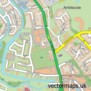
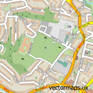
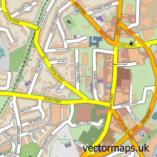
This Stourbridge street map is a detailed vector street map covering a 750m x 750m area. Select a larger area to create and download your own vector street map of Stourbridge.
The 750-metre map sample for Stourbridge covers 261 mapped buildings and approximately 70.1 km of road detail, of which 53 named roads are named. The immediate area includes 1 school, 1 railway station, 10 GP surgeries within 2 miles and 14 pubs among other local services. The wider area around Stourbridge features 6 tourism points of interest, 42 food and drink venues and 2 hotels. To create a larger or custom map of Stourbridge, the map builder lets you define your own coverage area and download editable SVG, PDF and PNG files.
Create a larger editable map of Stourbridge
Choose any area you need and generate a high-quality vector map instantly. Perfect for print, planning, design, business and personal use.

This Stourbridge street map in West Midlands is available as downloadable SVG, PDF and PNG map files, or as a printed map for planning, business, display, education, local information and design work. You can also create a larger custom map area using the map selector.
What this Stourbridge map sample shows
Stourbridge lies within Dudley District (B) parish, part of Wollaston And Stourbridge Town ward in the Dudley District (B) local authority area. The postcode geography for this area includes the DY postcode area, the DY8 postcode district and the DY8 1 postcode sector. Residents fall under the Nhs Black Country Integrated Care Board for NHS services.
Local features near Stourbridge
Within 2 milesAmenities and services in and around Stourbridge.
Administrative and postcode information for Stourbridge
The local authority covering Stourbridge is Dudley District (B), within the county of West Midlands. The settlement lies within Wollaston And Stourbridge Town ward and Dudley District (B) civil parish. The DY8 postcode district and DY8 1 postcode sector serve the immediate area. NHS provision in the area is delivered through The Dudley Group Nhs Foundation Trust.
Nearby street map samples around Stourbridge


More street maps in West Midlands
750 metre map area coverage
Boundary, postcode and point of interest information for the 750m x 750m rectangle centred on this sample map.
Boundaries containing map centre
Constituency: Stourbridge Boro Const
District: Dudley District (B)
Icb: NHS Black Country ICB
Police Force: west midlands
Postcode District: DY8
Postcode Sector: DY8 1
Ward: Wollaston & Stourbridge Town Ward
Nearby boundaries intersecting sample
Postcode Sector: DY8 3, DY8 4
Ward: Amblecote Ward, Lye & Stourbridge North Ward
Postcode coverage
POI category counts
Beauty Salon: 18
Hair Salon: 15
Flowers And Gifts Shop: 14
Pub: 14
Real Estate Agent: 14
Retail: 14
Bank Credit Union: 13
Clothing Store: 13
Coffee Shop: 12
Fast Food Restaurant: 12
Sample points of interest
- NPP Neuro Group
- Mariko Clinic
- Sue Morris Therapies
- Connexions Centre
- Direct 2 Print
- Moonflight
- Maxine Gohari
- Shipleys Amusement Centre
- St Thomas Church
- Extra Care Charitable Trust
- Scope Charity Shop
- MER Services
Create a larger editable map of Stourbridge
This sample shows only a 750 metre area. To create a larger map of Stourbridge, use our map builder to choose your own coverage area, add titles and download editable SVG, PDF and PNG files.
Create a custom map of Stourbridge