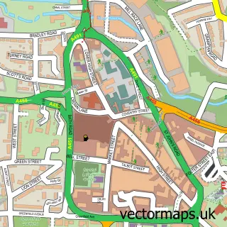
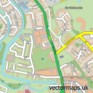
This Stourton street map is a detailed vector street map covering a 750m x 750m area. Select a larger area to create and download your own vector street map of Stourton.
The 750-metre map sample for Stourton covers 27 mapped buildings and approximately 11.4 km of road detail, of which 3 named roads are named. The wider area around Stourton features 1 tourism point of interest. To create a larger or custom map of Stourton, the map builder lets you define your own coverage area and download editable SVG, PDF and PNG files.
Create a larger editable map of Stourton
Choose any area you need and generate a high-quality vector map instantly. Perfect for print, planning, design, business and personal use.

This Stourton street map in Staffordshire is available as downloadable SVG, PDF and PNG map files, or as a printed map for planning, business, display, education, local information and design work. You can also create a larger custom map area using the map selector.
What this Stourton map sample shows
Stourton lies within Kinver Cp parish, part of Kinver ward in the South Staffordshire District local authority area. The postcode geography for this area includes the DY postcode area, the DY7 postcode district and the DY7 5 postcode sector. Residents fall under the Nhs Staffordshire And Stoke-On-Trent Integrated Care Board for NHS services.
Local features near Stourton
Within 2 milesAmenities and services in and around Stourton.
Administrative and postcode information for Stourton
Stourton lies within Kinver Cp parish, part of Kinver ward in the South Staffordshire District local authority area. The postcode geography for this area includes the DY postcode area, the DY7 postcode district and the DY7 5 postcode sector. Residents fall under the Nhs Staffordshire And Stoke-On-Trent Integrated Care Board for NHS services.
Nearby street map samples around Stourton

More street maps in Staffordshire
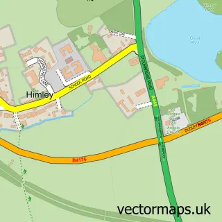
750 metre map area coverage
Boundary, postcode and point of interest information for the 750m x 750m rectangle centred on this sample map.
Boundaries containing map centre
Constituency: Kingswinford and South Staffordshire Co Const
County: Staffordshire County
District: South Staffordshire District
Icb: NHS Black Country ICB
Parish: Kinver CP
Police Force: staffordshire
Postcode District: DY7
Postcode Sector: DY7 5
Ward: Kinver & Enville Ward
Nearby boundaries intersecting sample
Postcode Sector: DY7 6
Postcode coverage
POI category counts
Garbage Collection Service: 1
Landmark And Historical Building: 1
Medical Center: 1
Printing Services: 1
Professional Services: 1
Sample points of interest
- Biffa Waste Management Stewponey
- Stewponey Apartment
- Physio4Neuro
- Rotary Club of Kinver
- Living Springs Family Centre
Create a larger editable map of Stourton
This sample shows only a 750 metre area. To create a larger map of Stourton, use our map builder to choose your own coverage area, add titles and download editable SVG, PDF and PNG files.
Create a custom map of Stourton