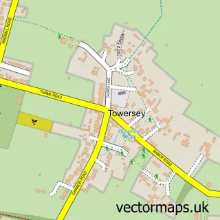
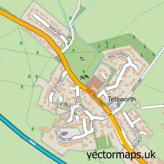
This Thame street map is a detailed vector street map covering a 750m x 750m area. Select a larger area to create and download your own vector street map of Thame.
The 750-metre map sample for Thame covers 388 mapped buildings and approximately 31.9 km of road detail, of which 47 named roads are named. The immediate area includes 2 schools, 1 GP surgery within 2 miles, 12 pubs and 1 MOT station, with 7 within 2 miles. The wider area around Thame features 2 tourism points of interest, 27 food and drink venues and 4 hotels. To create a larger or custom map of Thame, the map builder lets you define your own coverage area and download editable SVG, PDF and PNG files.
Create a larger editable map of Thame
Choose any area you need and generate a high-quality vector map instantly. Perfect for print, planning, design, business and personal use.

This Thame street map in Oxfordshire is available as downloadable SVG, PDF and PNG map files, or as a printed map for planning, business, display, education, local information and design work. You can also create a larger custom map area using the map selector.
What this Thame map sample shows
Thame lies within Thame Cp parish, part of Thame ward in the South Oxfordshire District local authority area. The postcode geography for this area includes the OX postcode area, the OX9 postcode district and the OX9 3 postcode sector. Residents fall under the Nhs Buckinghamshire, Oxfordshire And Berkshire West Integrated Care Board for NHS services.
Local features near Thame
Within 2 milesAmenities and services in and around Thame.
Administrative and postcode information for Thame
Thame lies within Thame Cp parish, part of Thame ward in the South Oxfordshire District local authority area. The postcode geography for this area includes the OX postcode area, the OX9 postcode district and the OX9 3 postcode sector. Residents fall under the Nhs Buckinghamshire, Oxfordshire And Berkshire West Integrated Care Board for NHS services.
Nearby street map samples around Thame

More street maps in Oxfordshire
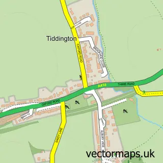
750 metre map area coverage
Boundary, postcode and point of interest information for the 750m x 750m rectangle centred on this sample map.
Boundaries containing map centre
Constituency: Henley and Thame Co Const
County: Oxfordshire County
District: South Oxfordshire District
Icb: NHS Thames Valley ICB
Parish: Thame CP
Police Force: thames valley
Postcode District: OX9
Postcode Sector: OX9 3
Ward: Thame Ward
Nearby boundaries intersecting sample
Postcode Sector: OX9 2
Postcode coverage
POI category counts
Professional Services: 20
Pub: 12
Real Estate Agent: 11
Beauty Salon: 8
Legal Services: 8
Charity Organization: 7
Clothing Store: 7
Hair Salon: 7
Advertising Agency: 6
Beauty And Spa: 6
Sample points of interest
- The Prebendal
- Fizz Accounting Ltd.
- Hart Nurse Ltd.
- Legal Eye
- In Depth Tours
- Marketing & Design Matters
- Pacific Marketing
- Red Dice
- Second 2
- Smokin Donut
- Rempstone Livestock
- Shutter Spec Security
Create a larger editable map of Thame
This sample shows only a 750 metre area. To create a larger map of Thame, use our map builder to choose your own coverage area, add titles and download editable SVG, PDF and PNG files.
Create a custom map of Thame